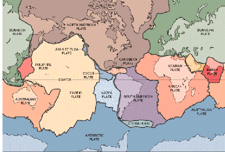
Plate Tectonic Theory
The acceptance of plate tectonic theory is
recognized as a major milestone in the geological sciences. It is comparable to the
revolution caused by Darwin's theory of evolution in biology. Plate tectonics has
provided a framework for interpreting the composition, structure, and internal processes
of the Earth on a global scale. It has led to the realization that the continents
and ocean basins are part of a lithosphere-atmosphere-hydrosphere (water portion of the
planet) system that evolved together with the Earth's interior.
According to plate tectonic theory, the lithosphere is
divided into plates that move over the atmosphere. Most of the boundaries between
plates are marked by zones of earthquake activity, volcanic activity, or both. Along
these boundaries, plates diverge, converge, or slide sideways past each other.
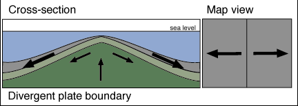
At divergent plate boundaries, plates move
apart as magma rises to the surface from the asthenosphere. The magma solidifies to
form rock, which attaches to the moving plates. The margins of divergent plate
boundaries are marked by mid-oceanic ridges in oceanic crust and are recognized by linear
rift valleys where newly forming divergent boundaries occur beneath continental
crust. The separation of South America from Africa and the formation of the South
Atlantic Ocean occurred along a divergent plate boundary, the Mid-Atlantic Ridge.
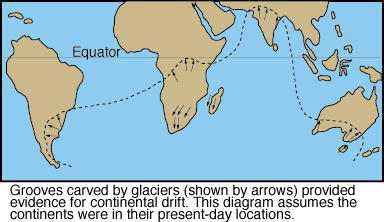
All of the Gondwana continents except Antarctica are currently located near the equator in subtropical to tropical climates. Mapping of glacial striations in bedrock in Australia, India, and South America indicates that the glaciers moved from the areas of the present-day oceans onto land. This would be highly unlikely because large continental glaciers flow outward from their central area of accumulation toward the sea.
If the continents did not move during the past, one would have to explain how glaciers moved from the oceans onto land and how large-scale continental glaciers formed near the equator. But if the continents are reassembled as a single landmass with South Africa located at the south pole, the direction of movement of Late Paleozoic continental glaciers makes sense. Furthermore, this geographic arrangement places the northern continents nearer the tropics, which is consistent with the fossil and climatological evidence from Laurasia.
Fossil Evidence
Some of the most compelling evidence for continental drift comes from the fossil record. Fossils of the Glossopteris flora are found in equivalent Pennsylvanian and Permian aged coal deposits on all five Gondwana continents. The Glossopteris flora is characterized by the seed fern Glossopteris as well as by many other distinctive and easily identifiable plants. Plant pollen and spores can be dispersed over great distances by wind, but Glossopteris type plants produced seeds that were too large to have been carried by winds. Even if the seeds had floated across the ocean, they probably would not have remained viable for any length of time in salt water. The present-day climates of South America, Africa, India, Australia, and Antarctica range from tropical to polar and are much too diverse to support the type of plants that compose the Glossopteris flora.
The fossil remains of animals also provide strong evidence for continental drift. One of the best examples is Mesosaurus, a freshwater reptile whose fossils are found in Permian-aged rocks in certain regions of Brazil and South Africa and nowhere else in the world. Because the physiology of freshwater and marine animals is completely different, it is hard to imagine how a freshwater reptile could have swum across the Atlantic Ocean and found a freshwater environment nearly identical to its former habitat. Moreover, if Mesosaurus could have swum across the ocean, its fossil remains should be widely dispersed. It is more logical to assume that Mesosaurus lived in lakes in what are now adjacent areas of South America and Africa, but were then united into a single continent.
Lystrosaurus and Cynognathus are both land-dwelling reptiles that lived during the Triassic Period; their fossils are found only on the present-day continental fragments of Gondwana. Because they are both land animals, they certainly could not have swum across the oceans currently separating the Gondwana continents. Therefore, the continents must once have been connected.
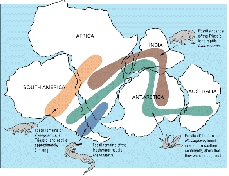
Plate Boundaries
Plates move relative to one another such that their boundaries can be characterized as divergent, convergent, and, transform. Interaction of plates at their boundaries account for most of the Earth's seismic and volcanic activity and, as will be apparent in the next chapter, the origin of mountain systems.
Divergent Boundaries
Divergent plate boundaries or spreading ridges occur where plates are separating and new oceanic lithosphere is forming. Divergent boundaries are places where the crust is being extended, thinned, and fractured as magma (derived from the partial melting of the mantle) rises to the surface. The magma is almost entirely basaltic and intrudes into vertical fractures to form dikes and lava flows. As successive injections of magma cool and solidify, they form new oceanic crust and record the intensity and orientation of the Earth's magnetic field. Divergent boundaries most commonly occur along the crests of oceanic ridges, for example, the Mid-Atlantic Ridge. Oceanic ridges are thus characterized by rugged topography with high relief resulting from displacement of rocks along large fractures, shallow-focus earthquakes, high heat flow, and basaltic flows or pillow lavas.
Divergent boundaries also occur under continents during the early stages of continental breakup. When magma wells up beneath a continent, the crust is initially elevated, extended, and thinned, producing fractures and rift valleys. During this stage, magma typically intrudes into the faults and fractures forming sills, dikes, and lava flows; the latter often cover the rift valley floor. The East African rift valley are an excellent example of this stage of continental breakup (it is often considered the birthplace for homo-sapiens; the changing conditions of the rift separated groups of hominids which in turn, evolved into different species).
If spreading proceeds, some rift valleys will continue to lengthen and deepen until they form a narrow linear sea separating two continental blocks. The Red Sea separating the Arabian Peninsula from Africa and the Gulf of California, which separates Baja California from mainland Mexico, are good examples of this more advanced stage of rifting.
As a newly created narrow sea continues enlarging, it may eventually become an expansive ocean basin such as the Atlantic, which separates North and South America from Europe and Africa by thousands of kilometers. The Mid-Atlantic Ridge is the boundary between these diverging plates; the American plates are moving westward, and the Eurasian and African plates are moving eastward.
Convergent Boundaries
Because new lithosphere is formed at divergent plate
boundaries, older lithosphere must be destroyed and recycled in order for the entire
surface area of the Earth to remain constant. Otherwise, we would have an expanding
Earth. Such plate destruction occurs at convergent plate boundaries
where two plates collide.
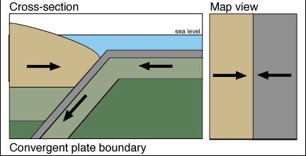
At a convergent boundary, the leading edge of one plate descends beneath the margin of the other by subduction. A dipping plane of earthquake foci, referred to as a Benioff zone, defines subduction zones. Most of these planes dip from oceanic trenches beneath adjacent island arcs or continents, marking the surface of slippage between the converging plates. As the subducting plate moves down into the asthenospere, it is heated and eventually incorporated into mantle. When both of the converging plates are continental, subduction does not occur because continental crust is not dense enough (its buoyant!) to be subducted into the mantle.
Convergent boundaries are characterized by deformation, volcanism, mountain building, metamorphism, seismeicity, and important mineral deposits. Three types of convergent plate boundaries are recognized: oceanic-oceanic, oceanic-continental, and continental-continental.
Oceanic-Oceanic Boundaries. When two oceanic plates converge, one of them is subducted beneath the other along an oceanic-oceanic plate boundary. The subducting plate bends downward to form the outer wall of an oceanic trench. A subduction complex, composed of wedge-shaped slices of highly folded and faulted marine sediments and oceanic lithosphere scraped off the descending plate, forms along the inner wall. As the subducting plate descends into the asthenospere, it is heated and partially melted, generating magma, commonly of andesitic composition. This magma is less dense than the surrounding mantle rocks and rises to the surface through the nonsubducting or overriding plate where it forms a curved chain of volcanoes called a volcanic island arc (any plane intersecting a sphere makes an arc). This arc is nearly parallel to the oceanic trench and is separated from it by up to several hundred kilometers - the distance depends on the angle of dip of the subducting plate.
In those areas where the rate of subduction is faster than the forward movement of the overriding plate, the lithosphere on the landward side of the volcanic island arc may be subjected to tensional stress and stretched and thinned, resulting in the formation of a back-arc basin. This back-arc basic may grow by spreading if the magma breaks through the thin crust and forms new oceanic crust. A good example of a back-arc basin associated with an oceanic-oceanic plate boundary is the Sea of Japan between the Asian continent and the island of Japan.
Most present-day active volcanic island arcs are in the Pacific Ocean basin and include the Aleutian Islands, the Kermadec-Tonga arc, and the Japanese and Philippine Islands. The Scotia and Antillean (Caribbean) island arcs are present in the Atlantic Ocean basin.
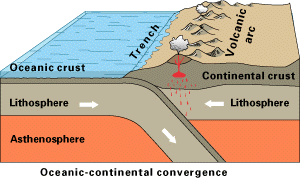
Oceanic-Continental Boundaries. When an oceanic and a continental plate converge, the denser oceanic plate is subducted under the continental plate along an oceanic-continental plate boundary. Just as at oceanic-oceanic plate boundaries, the descending oceanic plate forms the outer wall of an oceanic trench.
As the cold, wet, and slightly denser oceanic plate descends into the hot asthenospere, melting occurs and magma is generated. This magma rises beneath the overriding continental plate and can extrude at the surface, producing a chain of andesitic volcanoes (also called a volcanic arc), or intrude into the continental margin as plutons, especially batholiths. An excellent example of an oceanic-continental plate boundary is the Pacific coast of South America where the oceanic Nazca plate is currently being subducted under South America (which has produced the Andes Mountain Range as well as the well know underwater trench the 'Abyss').
Continental-Continental Boundaries.
When two continental plates converge along a continental-continental plate
boundary, one plate may partially slide under the other, but neither plate will
be subducted because of their low and equal densities and great thickness. These
continents are initially separated from one another by oceanic crust that is being
subducted under one of the continents. The edge of the continent will display the
characteristics of an oceanic-continental boundary with the development of a deep-sea
trench and volcanic arc. Eventually, the oceanic crust is totally consumed and the
two continents collide. The Himalayas, the world's youngest and highest mountain
system, resulted from the collision between India and Asia that began about 40 to 50
million years ago and is still continuing.
Transform Boundaries
The third type of plate boundary is a transform boundary. These occur along transform faults where plates slide laterally past one another roughly parallel to the direction of plate movement. Although lithosphere is neither created nor destroyed along a transform boundary, the movement between plates results in a zone of intensely shattered rock and numerous shallow-focus earthquakes.
Transform faults are particular types of faults that "transform" or change one type of motion between plates into another type of motion. The majority of transform faults connect two oceanic ridge segments, but they can also connect ridges to trenches and trenches to trenches. Though the majority of transform faults occur in oceanic crust and are marked by distinct fracture zones, they may also extend into continents.
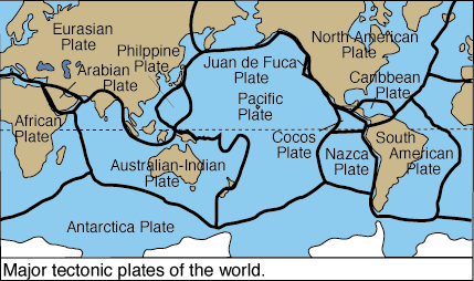
One of the best known transform faults is the San Andreas fault in California. It separates the Pacific plate from the North American plate and connects spreading ridges in the Gulf of California and off the coast of northern California. Many of the earthquakes affecting California are the result of movement along this fault.
The Driving Mechanism of Plate Tectonics
A major obstacle to the acceptance of continental drift was the lack of a driving mechanism to explain continental movement. When it was shown that continents and ocean floors moved together and not separately and that new crust formed at spreading ridges by rising magma, most geologists accepted some type of convective heat system as the basic process responsible for plate motion. However, the question of exactly what drives the plates still remains.
 Two models involving thermal convection cells have been
proposed to explain plate movement. In one model, thermal convection cells are
restricted to the asthenospere, whereas in the second model the entire mantle is involved.
In both models spreading ridges mark the ascending limbs of adjacent convection
cells, while trenches occur where the convection cells descend back into the Earth's
interior. The locations of spreading ridges and trenches are therefor determined by
the convection cells themselves, and the lithosphere is considered to be the top of the
thermal convection cell. Each plate thus corresponds to a single convection cell.
Two models involving thermal convection cells have been
proposed to explain plate movement. In one model, thermal convection cells are
restricted to the asthenospere, whereas in the second model the entire mantle is involved.
In both models spreading ridges mark the ascending limbs of adjacent convection
cells, while trenches occur where the convection cells descend back into the Earth's
interior. The locations of spreading ridges and trenches are therefor determined by
the convection cells themselves, and the lithosphere is considered to be the top of the
thermal convection cell. Each plate thus corresponds to a single convection cell.
Although most geologists agree that the Earth's internal heat plays an important role in plate movement, problems are inherent in both models. The major problem associated with the first model is the difficulty in explaining the source of heat for the convection cells and why they are restricted to the asthenosphere. In the second model, the source of heat comes from the Earth's outer core, but it is still not known how heat is transferred form the outer core to the mantle. Nor is it clear how convection can involve both the lower mantle and the asthenospere.
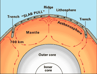
Some geologists think that in addition to thermal convection within the Earth, plate movement also occurs, in part, because of a mechanism involving "slab-pull" or "ridge-push". Both of these mechanisms are gravity driven, but still depend on thermal differences within the Earth. In "slab-pull," the subducting cold slab of lithosphere, being denser than the surrounding warmer asthenospere, pulls the rest of the plate along with it as it descends into the asthenospere. As the lithosphere moves downward, there is a corresponding upward flow back into the spreading ridge.
Operating in conjunction with "slab-pull" is the "ridge-push" mechanism. As a result of rising magma, the oceanic ridges are higher than the surrounding oceanic crust. It is through that gravity pushes the oceanic lithosphere away from the higher spreading ridges and toward the trenches.
Currently, geologists are fairly certain that some type of convective system is involved in plate movement, and the extent to which other mechanisms such as "slab-pull" and "ridge-push" are involved is still unresolved. Consequently, a comprehensive theory of plate movement has not yet been developed, and much still remains to be learned about the Earth's interior.