Running Water
Among the terrestrial planets, the Earth is unique in having abundant liquid water. Both Mercury and the Earth's moon are too small to retain water, and Venus, because of its runaway greenhouse effect, is too hot to retain surface water (it is gaseous instead of liquid). Mars has only some frozen water and trace amounts of water vapor in its atmosphere. In marked contrast, 71% of the Earth's surface is covered with water, and a small but important quantity of water vapor is present in its atmosphere.
The volume of water on Earth is estimated at 1.36 billion km^3, most of which (97.2%) is in the oceans. About 2% is frozen in glaciers, and the remaining 0.8% constitutes all the water in streams, lakes, swamps, groundwater, and the atmosphere. Thus, only a small portion of the total water on Earth is in streams, but running water is nevertheless the most important erosional agent modifying the Earth's surface.
Despite the importance of running water as an agent of erosion, sediment transports, and deposition, its role is limited in some areas. In areas covered by glacial ice, such as Greenland and Antarctica, running water is currently not important. Some parts of deserts are also little affected by running water. Even in most desert regions, though, the effects of running water are manifest, although the channels are dry most of the time.
In addition to its significance as a geologic agent, running water is important for many other reasons as well. It is a source of fresh (non-saline) water for industry, domestic use, and agriculture, and about 8% of the electricity used in North America is generated by falling water at hydroelectric stations. Streams have been, and continue to be, important avenues of commerce and much of the interior of North America was first explored by following such large streams as the St. Lawrence, Mississippi, and Missouri rivers.
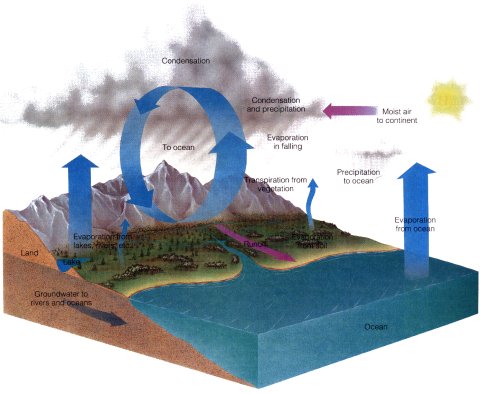
The Hydrologic Cycle
Although the quantity of water in streams is small at any one time, during the course of a year very large volumes of water move through stream channels. In fact, water is continually recycled from the oceans, through the atmosphere, to the continents, and back to the oceans. This continuous recycling of water is called the hydrologic cycle.
The hydrologic cycle, which is powered by solar radiation, is possible because water changes phases easily under Earth surface conditions. Huge quantities of water evaporate from the oceans each year as the surface waters are heated by solar energy. The amount of ocean water evaporated yearly corresponds to a layer about 1m thick from all the oceans. Approximately 85% of all water that enters the atmosphere is derived from the oceans; the remaining 15% comes from evaporation of water on land.
When water evaporates, the vapor rises into the atmosphere where the complex processes of condensation and cloud formation occur. About 80% of the precipitation falls directly into the oceans, in which case the hydrologic cycle is limited to a three-step process of evaporation, condensation, and precipitation.
About 20% of all precipitation falls on land as rain and snow. In this case, the hydrologic cycle involves more steps: evaporation, condensation, precipitation, and runoff and infiltration (groundwater). Some of the precipitation evaporates as it falls and reenters the hydrologic cycle as vapor; water evaporated from lakes and streams also reenters the cycle as vapor as does moisture evaporated from plants by transpiration.
Each year about 36,000km^3 of the precipitation falling on land returns to the oceans by runoff, the surface flow of streams. Of course, the amount of precipitation and runoff varies widely across the continents; some areas are extremely arid, whereas others receive hundreds of centimeters of precipitation yearly. In any case, the water returning to the oceans by runoff enters the Earth's ultimate reservoir where it begins the hydrologic cycle again.
Some of the precipitation falling on land is temporarily stored in lakes, snow fields, and glaciers or seeps below the surface where it is temporarily stored as groundwater. This water is effectively removed from the system for up to thousands of years, but eventually, glaciers melt, lakes feed streams, and groundwater flows into streams or directly into the oceans. Our concern here is with the comparatively small quantity returning to the oceans as runoff, for the energy of running water is responsible for a great many surface features.
Running Water
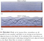
Water possesses no strength so it will flow on any slope no matter how slight. The flow of water, or any other fluid, can be characterized as laminar or turbulent. In laminar flow, lines of flow called streamlines are all parallel with one another. In other words, all flow occurs in parallel layers with no mixing between layers. By contrast, in turbulent flow, the streamlines intertwine, causing a complex mixing of the fluid.
Laminar flow is most easily observed in viscous fluids such as cold motor oil or syrup. One can also see laminar flow in parking lots where a thin film of water containing oil moves slowly over the surface. Turbulent flow, on the other hand, occurs in all streams. The primary control on the type of flow is velocity; roughness of the surface over which it flow occurs also plays a role. Laminar flow occurs when water flows very slowly, as when groundwater moves through the tiny pores in sediments as soil. In streams, however, the flow is usually fast enough and the channel walls and bed rough enough so that flow is fully turbulent. Laminar flow is so slow, and generally so shallow, that it causes little or no erosion. Turbulent flow is much more energetic and is capable of considerable erosion and sediment transport.
Sheet Flow versus Channel Flow
The amount of runoff in any area during a rainstorm depends on the infiltration capacity, the maximum rate at which soil or other surface materials can absorb water. Infiltration capacity depends on several factors, including the intensity and duration of rainfall. Loosely packed, dry soils absorb water faster than tightly packed, wet soils. Hard, dry surfaces, such as those that develop during droughts, also have low infiltration capacities. Therefore, when they do receive rain, there is still considerable runoff.
If rain is absorbed as fast as it falls, no surface runoff occurs. Should the infiltration capacity be exceeded, or should surface materials become saturated, excess water collects on the surface and, if a slope exists, moves downhill. Even on steep slopes such flow is initially slow, and hence little or no erosion occurs. As the water moves downslope, however, it accelerates and may move by sheet flow, a more or less continuous film of water flowing over the surface. Sheet flow is not confined to depressions, and it accounts for sheet erosion, a particular problem on some agricultural lands.
In channel flow, surface runoff is confined to long, trough-like depressions. Channels vary in size from rills containing a trickling stream of water to the Amazon River of South America, which is 6,450km long and up to 2,4km wide and 90m deep. Channelized flow is described by various terms including rill, brook, creek, stream, and river, most of which are distinguished by size and volume. The term stream carries no connotation of size and is used here to refer to all runoff confined to channels regardless of size.
Streams receive water from several sources, including sheet flow and rain falling directly into stream channels. Far more important, though, is the water supplied by soil moisture and groundwater, both of which flow downslope and discharge into streams. In humid areas where groundwater is plentiful, streams may maintain a fairly stable flow year round, even during dry seasons, because they are continually supplied by groundwater. In contrast, the amount of water in streams of arid and semiarid regions fluctuates widely because these streams depend more on infrequent rainstorms and surface runoff for their water supply.
Stream Gradient
Streams flow downhill from a source area to a lower elevation where they empty into another stream, a lake, or the sea. The flow of certain desert streams diminishes in a downstream direction by evaporation and infiltration until the streams disappear. The slope over which a stream flows is its gradient. For example, if the source (headwaters) of a stream is 1,000m above sea level and the stream flows 500km to the sea, it drops 1,000m vertically over a horizontal distance; in this example, it is 1,000m/500km = 2m/km.
Gradients vary considerably, even along the course of a single stream. Generally, streams are steeper in their upper reaches where their stream gradient may be tens of meters per kilometer, but in their lower reaches the gradient may be as little as a few centimeters per kilometer. Some streams in mountainous regions have particularly steep gradients of several hundred meters per kilometer.
Velocity and Discharge
Stream velocity and discharge are closely related variables. Velocity is simply a measure of the downstream distance traveled per unit of time. Velocity is usually expressed in feet per second (ft/sec) or meters per second (m/sec) and varies considerably among streams and even within the same stream.
Variations in flow velocity occur not only with distance along a stream channel but also across a channel's width. For example, because friction, flow velocity is slower and more turbulent near a stream's bed and banks than it is farther from these boundaries. The bed and banks cause frictional resistance to flow, whereas the water some distance away is unaffected by friction and has a higher velocity.
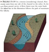
Other controls on velocity include channel shape and roughness. Broad, shallow channels and narrow, deep channels have proportionally more water in contact with their perimeters than do channels with semicircular cross sections. Consequently, water in semicircular channels flows more rapidly because it encounters less frictional resistance. In many streams the maximum flow velocity occurs near the surface at the center of the channel; it occurs slightly below the surface because of frictional resistance from the air above. In sinuous (meandering) channels, however, the line of maximum flow velocity switches form one side of the channel to the other and corresponds to the channel center only along straight reaches.

Channel roughness is a measure of the frictional resistance within a channel. Frictional resistance to flow is greater in a channel containing large boulders than in one with banks and a bed composed of sand or clay. In channels with abundant vegetation, flow is slower than in barren channels of comparable size.
The most obvious control on velocity is gradient, and one might think that the steeper the gradient, the greater the flow velocity. In fact, the average velocity generally increases in a downstream direction, even though the gradient decreases in the same direction. Three factors contribute to this: First, velocity increases continuously, even as gradient decreases, in response to the acceleration of gravity unless other factors retard flow. Secondly, in their upstream reaches, streams commonly have boulder-strewn, broad, shallow channels, so flow resistance is high and velocity is correspondingly slower. Downstream, however, channels generally become more semicircular, and the bed and banks are usually composed of finer-grained materials, thus reducing the effects of friction. Thirdly, the number of tributary streams joining a larger stream increases in a downstream direction. Thus, the total volume of water (discharge) increases, and increasing discharge results in increased velocity.
Discharge is the total volume of water in a stream moving past a particular point in a given period of time. To determine discharge, one must know the dimensions of a channel, that is, it's cross sectional area (A), and its flow velocity (V). Discharge (Q) can then be calculated by the formula Q=VA, and it is generally expressed in cubic feet per second (ft^3/sec) or cubic meters per second (m^3/sec). The Mississippi River has an average discharge of 18,000 m^3/sec, but, as for all streams, the discharge varies, being greatest during floods and lowest during long, dry spells.
Stream Erosion
Streams possess two kinds of energy, potential and kinetic. Potential energy is the energy of position, such as that possessed by water behind a dam or at a high elevation. In stream flow, potential energy is converted to kinetic energy, the energy of motion. Moth of this kinetic energy is dissipated as heat within streams by fluid turbulence, but a small amount, perhaps 5%, is available to erode and transport sediment. Erosion involves the physical removal of dissolved substances and loose particles of soil and rock from a source area. Thus, the sediment transported in a stream consists of both dissolved materials and solid particles.
Because the dissolved load of a stream is invisible, it is commonly overlooked, but it is an important part of the total sediment load. Some of it is acquired from the stream bed and banks where soluble rocks such as limestone and dolostone are exposed, but much of it is carried into streams by sheet flow and by groundwater.
The solid sediment carried in streams ranges from clay-sized particles to large boulders. Much of this sediment is supplied to streams by mass wasting, but some is derived directly from the stream bed and banks. The power of running water, called hydraulic action, is sufficient to set particles in motion. Everyone has seen the results of hydraulic action, although perhaps not in streams. For example, if the flow from a garden hose is directed onto loose soil, a hole is soon gouged out by hydraulic action.
Another process of erosion in streams is abrasion, in which exposed rock is worn and scraped by the impact of solid particles. If running water contains no sediment, little or no erosion of solid rock surfaces will result, but if it is transporting sand and gravel, the impact of these particles abrades exposed rock surfaces. Potholes in the bed of streams are one obvious manifestation of abrasion. These circular to oval holes occur where eddying currents containing sand and gravel swirl around and erode depressions into solid rock.
Transport of Sediment Load
Steams transport a solid load of sedimentary particles and a dissolved load consisting of ions taken into solution by chemical weathering. Sedimentary particles are transported either as suspended load or as bed load. Suspended load consists of the smaller particles, such as silt and clay, which are kept suspended by fluid turbulence. The Mississippi River transports nearly 200 million metric tons of suspended load past Vicksburg, Mississippi each year, and the Yellow River of China carries almost four times as much suspended load per year. Particles transported in suspension are deposited only where turbulence is minimal as in lakes or the quiet offshore waters of the sea.
Bed load consists of the coarser particles such as sand and gravel. Fluid turbulence is insufficient to keep such large particles suspended, so they move along the stream bed. Part of the bed load can be suspended temporarily as when an eddying current swirls across a streams bed and lifts sand grains into the water. These particles move forward at approximately the flow of velocity, but at the same time they settle toward the stream bed where they come to rest, to be moved again later by the same process. This process of intermittent bouncing and skipping along the stream bed is called saltation.
Particles too large to be suspended even temporarily are transported by rolling or sliding. Obviously, greater flow velocity is required to move particles of these sizes. The maximum-sized particles that a stream can carry define its competence, a factor related to flow velocity.
Capacity is a measure of the total load a stream can carry. It varies as a function of discharge; with greater discharge, more sediment can be carried. Capacity and competence may seem quite similar, but they are actually related to different aspects of stream transport. For instance, a small, swiftly flowing steam may have the competence to move gravel-sized particles but not to transport a large volume of sediment, so it has a low capacity. A large, slow-flowing stream, on the other hand, has a low competence, but may have a very large suspended load, and hence a large capacity.
Stream Deposition
Streams can transport sediment a considerable distance from the source area. Some of the sediments deposited in the Gulf of Mexico by the Mississippi River came from such distant sources as Pennsylvania, Minnesota, and southern Alberta, Canada. Along the way, deposition may occur in a variety of environments, such as stream channels, the floodplains adjacent to channels, and the points where streams flow into lakes or the seas or flow from mountain valleys onto adjacent lowlands.
Streams do most of their erosion, sediment transport, and deposition when they flood. Consequently, streams deposits, collectively called alluvium, do not represent the continuous day-to-day activity of streams, but rather those periodic, large-scale events of sedimentation associated with flooding.
Braided Streams and Their Deposits
Braided streams possess an intricated network of dividing and rejoining channels. Braiding develops when a stream is supplied with excessive sediment, which over time is deposited as sand and gravel bars within its channel. During high-water stages, these bars are submerged, but during low-water stages, they are exposed and divide channel into multiple channels. Braided streams have broad, shallow channels. They are generally characterized as bed load transport streams, and their deposits are composed mostly of sheets of sand and gravel.
Braided streams are common in arid and semiarid regions where there is little vegetation and erosion rates are high. Streams with easily eroded banks are also likely to become braided. In fact, a stream that is braided where its banks are easily eroded may have a single, sinuous or meandering channel when it flows into an area of more resistant materials. Streams fed by melting glaciers are also commonly braided because the melting glacial ice yields so much sediment.
Meandering Streams and Their Deposits
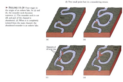
Meandering streams have a single, sinuous channel with broadly looping curves called meanders. Such stream channels are semicircular in cross section along straight reaches, but at meanders they are markedly asymmetric, being deepest near the outer bank, which commonly descends vertically into the channel. The outer bank is called the cut bank because flow velocity is at a minimum near the inner bank, which slopes gently into the channel.
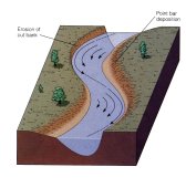
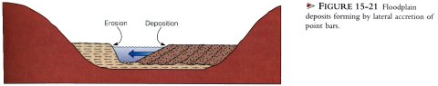
As a consequence of the unequal distribution of flow velocity across meanders, the cut bank is eroded, and deposition occurs along the opposite side of the channel. The net effect is that a meander migrates laterally, and the channel maintains a more or less constant width because erosion on the cut bank is offset by an equal amount of deposition on the opposite side of the channel. The deposit formed in this manner is a point bar; it consists of cross-bedded sand or, in some cases, gravel. Point bars are the characteristic deposits that accumulate within meandering stream channels.
It is not uncommon for meanders to become so sinuous that the thin neck of land separating adjacent meanders is eventually cut off during a flood. The valley floors of meandering streams are commonly marked by crescent-shaped oxbow lakes, which are actually cutoff meanders. These oxbow lakes may persist as lakes for some time, but are eventually filled with organic matter and fine-grained sediment carried by floods. Once filled, oxbow lakes are called meander scars.
One immediate effect of meander cutoff is an increase in flow velocity; following the cutoff, the stream abandons part of its old course and flows a shorter distance, thereby increasing its gradient. Numerous cutoffs would, of course, significantly shorten a meandering stream, but streams usually establish new meanders elsewhere when old ones are cut off.
Floods and Floodplain Deposits
Most streams periodically receive more water than either channel can carry, so they spread across low-lying, relatively flat areas called floodplains adjacent to their channels. Even small streams commonly have a floodplain, but this feature is usually proportional to the size of the stream; thus, small streams have narrow floodplains, whereas the lower Mississippi and other large streams have floodplains many kilometers wide. Streams restricted to deep, narrow valleys usually have little or no floodplain.
Some floodplains are composed mostly of sand and gravel that were deposited as point bars. When a meandering stream erodes its cut bank and deposits on the opposite bank, it migrates laterally across its floodplain. As lateral migration occurs, a succession of point bars develops by lateral accretion. That is, the deposits build laterally as a result of repeated episodes of sedimentation on the inner banks of meanders.
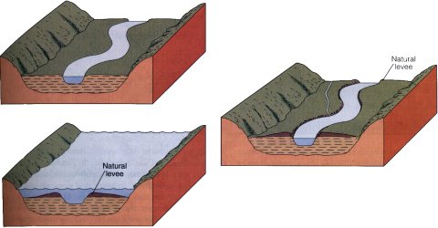
Many floodplains are dominated by vertical accretion of fine-grained sediments. When a stream overflows its banks and floods, the velocity of the water spilling onto the floodplain diminishes rapidly because of greater frictional resistance to flow as the water spreads out as a broad, shallow sheet. In response to the diminished velocity, ridges of sandy alluvium called natural levees are deposited along the margins of the stream channel. Natural levees are built up by repeated deposition of sediment during numerous floods. These natural levees separate most of the floodplain from the stream channel, so floodplains are commonly poorly drained and swampy. In fact, tributary streams may parallel the natural levee system.
The floodwaters spilling from a main channel carry large quantities of silt- and clay-sized sediment beyond the natural levees and onto the floodplain. During the waning stages of a flood, the floodwaters may flow very slowly or not at all, and suspended silt and clay eventually settle as layers of mad that build upward by deposition during successive floods.
Deltas
The fundamental process of delta formation is rather simple: when a stream flows into another body of water, its flow velocity decreases rapidly and deposition occurs. As a result of such deposition, a delta forms, causing the local shoreline to build out, or prograde. Deltas in lakes are common, but marine deltas are much larger and far more complex.
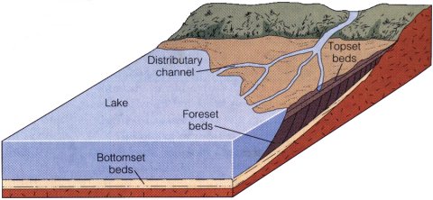
The simplest prograding deltas exhibit a characteristic vertical sequence in which bottomset beds are successively overlain by forest beds and topset beds. These sequences develop when a stream enters another body of water, and the finest sediments are carried some distance beyond the streams mouth, where they settle from suspension and form bottomset beds. Nearer the stream's mouth, foreset beds and formed as sand and silt are deposited in gently inclined layers. The topset beds consist of coarse-grained sediments deposited in a network of distributary channels traversing the top of the delta. In effect, streams lengthen their channel as they extend across prograding deltas.
Many small deltas in lakes have the three-part division described above, but large marine deltas are usually much more complex. Depending on the relative importance of stream, wave, and tidal processes, three major types of marine deltas are recognized. Stream-dominated deltas, such as the Mississippi River delta, consist of long fingerlike sand bodies, each deposited in a distributary channel that progrades far seaward. These deltas are commonly called bird's-foot deltas because the projections resemble the toes of a bird. In contrast, the Nile delta of Egypt is wave-dominated, although it also possesses distributary channels; the seaward margin of the delta consists of a series of barrier islands formed by reworking of sediments by waves, and the entire margin of the delta progrades seaward. Tide-dominated deltas, such as the Ganges-Brahmaputra of Bangladesh, are continually modified into tidal sand bodies that parallel the direction of tidal flow.
Coal can form in several depositional environments, such as the fresh water marshes between distributary channels of deltas. These marshes are dominated by non-woody plants whose remains accumulate to form peat, the first stage in the origin of coal. If peat is buried, the volatile components of the plants are driven off leaving mostly carbon that eventually forms coal.
Delta progradation is one way that potential reservoirs for oil and gas form. Because of their porosity and permeability and association with organic-rich marine sediments, distributary sand bodies commonly contain oil and gas. Much of the oil and gas production of the Gulf Coast of Texas comes from buried delta deposits. Some of the older deposits of the Niger River delta of Africa and the Mississippi River delta are also known to contain vast reserves of oil and gas.
Alluvial Fans
Alluvial fans are lobate deposits on land. They form best on lowlands adjacent to highlands in arid and semiarid regions where little or no vegetation exists to stabilize surface materials. When periodic rainstorms occur, surface materials are quickly saturated and runoff begins. During a particularly heavy rain, all of the surface flow in a drainage area is funneled into a mountain canyon leading to an adjacent lowland. The stream is confined in the mountain canyon so that it cannot spread laterally. But as it discharges from the canyon onto the lowland area, it quickly spreads out, its velocity diminishes, and deposition ensues.
The alluvial fans that develop by the process just described are mostly accumulations of sand and gravel, a large proportion of which is deposited by streams. In some cases the water flowing through a mountain canyon picks up so much sediment that it becomes a viscous mudflow. Consequently, mudflow deposits make up a large part of some alluvial fans.
Drainage Basins and Drainage Patterns
Thousands of streams, most of which are parts of larger drainage systems, flow either directly or indirectly into the oceans. A stream such as the Mississippi River consists of a main stream and all of the smaller tributary streams that supply water to it. The Mississippi River and all of its tributaries, or any other drainage system for that matter, carry surface runoff from an area known as the drainage basin. Individual drainage basins are separated from adjacent ones by topographically higher areas called divides. Some divides are rather modest rises, such as that separating the Great Lakes' drainage basin from the of the Mississippi River, whereas others, such as the Continental Divide along the crest of the Rocky Mountains, are more impressive.
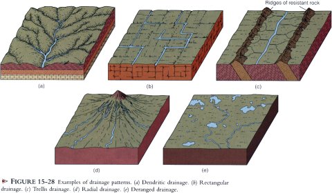
Various drainage patterns are recognized based on the regional arrangements of channels in a drainage system. The most common is dendritic drainage, which consists of a network of channels resembling tree branching. Dendritic drainage develops on gently sloping surfaces where the materials respond more or less homogeneously to erosion. Areas of flat-lying sedimentary rocks and some terrains of igneous or metamorphic rocks usually display a dendritic drainage pattern.
In marked contrast to dendritic drainage in which tributaries join larger streams at various angles, rectangular drainage is characterized by channels with right angle bends and tributaries that join larger streams at right angles. The position of the channels are strongly controlled by geologic structures, particularly regional joint systems that intersect at right angles. Rectangular drainage develops because streams more easily erode and establish channels along the traces of joints.
In some parts of the eastern United States, such as Virginia and Pennsylvania, erosion of folded sedimentary rocks develops a landscape of alternating parallel ridges and valleys. The ridges consist of more resistant rocks such as sandstone, whereas the valleys overlie less resistant rock such as shale. Main streams follow the trends of the valleys. Short tributaries flowing from the adjacent ridges join the main stream at nearly right angles, hence the name trellis drainage.
In radial drainage, streams flow outward in all directions from a central high area. Radial drainage develops on large, isolated volcanic mountains, such as Mount Shasta in California, and where the Earth's crust has been arched up by the intrusion of plutons such as laccoliths.
In some areas streams flow in and out of swamps and lakes with irregular flow directions. Drainage patterns characterized by such irregularity are called deranged. The presence of deranged drainage indicates that the drainage system developed recently and has not yet formed an organized system. In areas of Minnesota, Wisconsin, and Michigan that were glaciated until about 10,000 years ago, the previously established drainage systems were obliterated by glacial ice. Following the final retreat of the glaciers, drainage systems became established, but have not yet become fully organized.
Base Level
Streams require a slope in order to flow, so they can erode downward only to the level of the body of water into which they discharge. A stream flowing into the sea, for example, cannot erode its valley lower than sea level, if it could, it would have to flow uphill to reach the sea. The lower limit to which streams can erode is called base level. Theoretically, a stream could erode its entire valley to very near sea level, so sea level is commonly referred to as ultimate base level. Streams never reach ultimate base level, though, because they must have some gradient in order to maintain flow. Streams flowing into depressions below sea level, such as Death Valley in California, have a base level corresponding to the lowest point of the depression and are not limited by sea level.
In addition to ultimate base level, streams have local or temporary base levels. A lake or another stream can serve as a local base level for the upstream segment of a stream. Likewise, where a stream flows across particularly resistant rock, a waterfall may develop, forming a local base level. The escarpment Niagara Falls plunges over is a good example of a local or temporary base level.
When sea level rises of falls with respect to the land, or the land over which a stream flows is uplifted or subsides, changes in base level occur. For example, during the Pleistocene Epoch when extensive glaciers were present on the Northern Hemisphere continents, sea level was more than 100m lower than at present. Accordingly, streams deepened their valleys by adjusting to a new, lower base level. In addition, many streams extended their valleys onto the exposed continental shelves. Rising sea level at the end of the Pleistocene caused base level to rise, and the streams responded by depositing sediments and backfilling previously formed valleys.
Streams adjust to human intervention, but not always in anticipated or desirable ways. Geologists and engineers are well aware that the process of building a dam and impounding a reservoir creates a local base level. Where a stream enters a reservoir, its flow velocity diminishes rapidly and deposition occurs, so reservoirs are eventually filled with sediments unless they are dredged. Another consequence of building a dam is that the water discharge at the dam is largely sediment free, but it still possesses energy to transport sediment. Commonly, such streams simply acquire a new sediment load by vigorously eroding downstream from the dam.
Draining a lake along a stream's course may seem like a small change that is well worth the time and expense to expose dry land for agriculture or commercial development. But unless one anticipates the stream's probable response, dire consequences can result. Remember that a lake is a temporary base level, so draining it lowers the base level for that part of the stream above the lake, and the stream will very likely respond by rapid downcutting.
The Graded Stream
A stream's longitudinal profile shows the elevations of a channel along its length as viewed in cross section. The longitudinal profiles of many streams show a number of irregularities such as lakes and waterfalls, which are local base levels. Over time such irregularities tend to be eliminated by stream processes; where the gradient is steep, erosion decreases it, and where the gradient is too low to maintain sufficient flow velocity for sediment transport, deposition occurs, steepening the gradient. In short, streams tend to develop a smooth, concave longitudinal profile of equilibrium, meaning that all parts of the system are dynamically adjusting to one another.
Streams possessing an equilibrium profile are said to be graded streams; that is, a delicate balance exists between gradient, discharge, flow velocity, channel characteristics, and sediment load such that neither significant erosion nor deposition occurs within the channel. Such a delicate balance is rarely attained, so the concept of a graded stream is an ideal. Nevertheless, many streams do indeed approximate the graded stream condition, although not along their entire courses and usually only temporarily.
Even though the concept of a graded stream is an ideal, we can generally anticipate the responses of a graded stream to changes altering its equilibrium. A change in base level would cause a stream to adjust as previously discussed. Increased rainfall in a stream's drainage basin would result in greater discharge and flow velocity. In short, the stream would now possess greater energy..energy that must be dissipated within the streams system by, for example, a change in channel shape. A change from a semicircular to a broad, shallow channel would dissipate more energy by friction. On the other hand, the stream may respond by active downcutting in which it erodes a deeper valley and effectively reduces its gradient until it is once again graded.
Vegetation inhibits erosion by having a stabilizing effect on soil and other loose surface materials. So a decrease in vegetation in a drainage basin might lead to a higher erosion rates, causing more sediment to be washed into a stream than it can effectively carry. Accordingly, the stream may respond by deposition within its channel, which increases the stream's gradient until it is sufficiently steep to transport the greater sediment load.
Development of Stream Valleys
Valleys are common landforms, and with few exceptions they form and evolve as a consequence of stream erosion, although other processes, especially mass wasting, also contribute. The shapes and sizes of valleys vary considerably; some are small, steep-sided gullies, whereas others are broad and have gently sloping valley walls. Some steep-walled, deep valleys of vast proportions are called canyons. The Grand Canyon of Arizona, for example, is an interconnected system of canyons eroded by the Colorado River and its tributaries. Particularly narrow and deep valleys are gorges, for example the Nantahala Gorge in the Nantahala National Forest, North Carolina, carved by the Nantahala River.
A valley may begin where runoff has sufficient energy to dislodge surface materials and excavate a small rill. Once formed, a rill collects more surface runoff and becomes deeper and wider until a full-fledged valley develops. Several processes are involved in the origin and evolution of valleys, including downcutting, lateral erosion, mass wasting, sheet wash, and headward erosion.
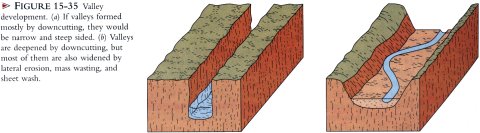
Downcutting occurs when a stream possess more energy than it requires to transport its sediment load, so some of its excess energy cuts its valley deeper. If downcutting were the only process operating, valleys would be narrow and steep sided. In most cases, however, the valley walls are undercut by the stream. Such undermining, termed lateral erosion, creates unstable conditions so that part of a bank or valley wall may move downslope by any one or a combination of mass wasting processes. Furthermore, sheet wash and erosion of rill and gully tributaries carry material from the valley walls into the main stream.
In addition to becoming deeper and wider, stream valleys are commonly lengthened as well. Valleys are lengthened in an upstream direction by headward erosion as drainage divides are eroded by entering runoff water. In some cases headward erosion eventually breaches the drainage divide and diverts part of the drainage of another stream by a process called stream piracy. Once stream piracy has occurred, both drainage systems must adjust; one now has more water, greater discharge, and greater potential to erode and transport sediment, whereas the other is diminishing in all of these aspects.
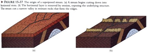
Superposed Streams
Streams flow downhill in response to gravity, so their courses are determined by preexisting topography. Yet a number of streams seem, at first glance, to have defined this fundamental control. For example, the Delaware, Potomac, and Susquehanna rivers in the eastern United States have valleys that cut directly through ridges lying in their paths. All of these streams are superposed. In order to understand how superposition occurs, it is necessary to know the geologic histories of these streams.
During the Mesozoic Era, the Appalachian Mountain region was eroded to a sediment-covered plain crossed by numerous streams generally flowing eastward. During the Cenozoic Era, regional uplift commenced, and the streams eroded downward and were superposed directly upon resistant rock. Instead of changing course, they cut narrow, steep-walled canyons called water gaps.
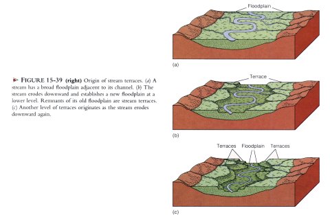
Stream Terraces
Adjacent to many streams are erosional remnants of flood-plains formed when the streams were flowing at a higher level. These erosional remnants are stream terraces. They consists of a fairly flat upper surface and a steep slope descending to the level of the lower, present-day floodplain. In some cases, a stream has several step-like surfaces above its present-day floodplain, indicating that stream terraces formed several times.
Although all stream terraces result from erosion, they are preceded by an episode of floodplain formation and deposition of sediment. Subsequent erosion causes the stream to cut downward until it is once again graded. Once the stream again becomes graded, it begins eroding laterally and establishes a new floodplain at a lower level. Several such episodes account for the multiple terrace levels seen adjacent to some streams.
Stream terraces are commonly cut into previously deposited sediment, but some are cut into bedrock. Where they are cut into bedrock, the terrace surface is generally covered by a thin veneer of sediment. In many stream valleys, terraces are paired, meaning that they occur at the same elevation on opposite sides of the channel.
Renewed erosion and the formation of stream terraces are usually attributed to a change in base level. Either uplift of the land over which a stream flows or lowering of sea level yields a steeper gradient and increased flow velocity, thus initiating an episode of downcutting. When the stream reaches a level at which it is once again graded, downcutting ceases.
Although changes in base level no doubt account for many stream terraces, greater runoff in a stream's drainage basic can also result in the formation of terraces. Recall that one of the variables controlling velocity is discharge, so a stream can erode downward and form terraces with no change in base level.
Incised Meanders
Some streams are restricted to deep, meandering canyon cut into solid bedrock, where they form features called incised meanders. The San Juan River in Utah, for example, occupies a meandering canyon more than 390m deep. Such streams, being restricted by solid rock walls, are generally ineffective in eroding laterally; thus, they lack a floodplain and occupy the entire width of the canyon floor. Some incised meandering streams do erode laterally, thereby cutting off meanders and producing natural bridges.
It is not difficult to understand how a stream can cut downward into solid rock, but forming a meandering pattern in bedrock is another matter. Because lateral erosion is inhibited once downcutting begins, one must infer that the meandering course was established when the stream flowed across an area covered by alluvium. For instance, suppose that a stream near base level has established a meandering pattern. If the land over which the stream flows is uplifted, erosion is initiated, and the meanders become incised into the underlying bedrock.
Uplift does not account for all incised meanders. A stream far above sea level can establish a meandering pattern provided that it flows over a gently sloping surface. The meandering pattern was already established before erosion into bedrock occurred.