Groundwater
Groundwater the water stored in the open spaces within underground rocks and unconsolidated material is a valuable natural resource that is essential to the lives of all people. Its importance to humans is not new. Groundwater rights have always been important in North America, and many legal battles have been fought over them. Groundwater also played a crucial role in the development of the U.S. railway system during the nineteenth century when railroads needed a reliable source of water for their steam locomotives. Much of the water used by the locomotives came from groundwater tapped by wells.
Today, the study of groundwater and its movement has become increasingly important as the demand for fresh water by agricultural, industrial, and domestic users has reached an all-time high. More than 65% of the groundwater used in the United States each year goes for irrigation, with industrial use second, followed by domestic needs. These demands have severely depleted the groundwater supply in many areas and led to such problems as ground subsidence and saltwater contamination. In other areas, pollution from landfills, toxic waste, and agriculture has rendered the groundwater supply unsafe.
As the world’s population and industrial development expand, the demand for water, particularly groundwater, will increase. Not only is it important to locate new groundwater sources, but, once found, these sources must be protected from pollution and managed properly to ensure that users do not withdraw more water than can be replenished.
Groundwater And The Hydrologic Cycle
Groundwater represents approximately 22% (8.4 million kmł) of the world’s supply of fresh water. This amount is about 36 times greater than the total for all of the streams and lakes of the world and equals about one-third the amount locked up in the world’s ice caps. If the world’s groundwater were spread evenly over the Earth’s surface, it would be about 10 m deep.
Groundwater is one reservoir of the hydrologic cycle. The major source of groundwater is precipitation that infiltrates the ground and moves through the soil and pore spaces of rocks. Other sources include water infiltrating from lakes and streams, recharge ponds, and wastewater treatment systems. As the groundwater moves through soil, sediment, and rocks, many of its impurities, such as disease-causing microorganisms, are filtered out. Not all soils and rocks are good filters, however, and some serious pollutants are not removed. Groundwater eventually returns to the surface reservoir when it enters lakes, streams, or the ocean.
Porosity And Permeability
Porosity and permeability are important physical properties of Earth materials and are largely responsible for the amount, availability, and movement of groundwater. Water soaks into the ground because the soil, sediment, or rock has open spaces or pores. Porosity is the percentage of a material’s total volume that is pore space. While porosity most often consists of the spaces between particles in soil, sediments, and sedimentary rocks, other types of porosity can include cracks, fractures, faults, and vesicles in volcanic rocks.
Porosity varies among different rock types and is dependent on the size, shape, and arrangement of the material composing the rock. Most igneous and metamorphic rocks as well as many limestones and dolostones have very low porosity because they are composed of tightly interlocking crystals. Their porosity can be increased, however, if they have been fractured or weathered by groundwater. This is particularly true for massive limestone and dolostone whose fractures can be enlarged by acidic groundwater.
By contrast, detrital sedimentary rocks composed of well-sorted and well-rounded grains can have very high porosity because any two grains touch only at a single point, leaving relatively large open spaces between the grains. Poorly sorted sedimentary rocks, on the other hand, typically have low porosity because finer grains fill in the space between the larger grains, further reducing porosity. In addition, the amount of cement between grains can also decrease porosity.
Although porosity determines the amount of groundwater a rock can hold, it does not guarantee that the water can be extracted. The capacity of a material for transmitting fluids is its permeability. Permeability is dependent not only on porosity, but also on the size of the pores or fractures and their interconnections. For example, deposits of silt or clay are typically more porous than sand or gravel. Nevertheless, shale has low permeability because the pores between its clay particles are very small, and the molecular attraction between the clay and the water is great, thereby preventing movement of the water. In contrast, the pore spaces between grains in sandstone and conglomerate are much larger, and the molecular attraction on the water is therefore low. Chemical and biochemical sedimentary rocks, such as limestone and dolostone, and many igneous and metamorphic rocks that are highly fractured can also be very permeable provided that the fractures are interconnected.
A permeable layer transporting groundwater is called an aquifer, from the Latin aqua meaning water. The most effective aquifers are deposits of well-sorted and well rounded sand and gravel. Limestones in which fractures and bedding planes have been enlarged by solution are also good aquifers. Shales and many igneous and metamorphic rocks make poor aquifers because they are typically impermeable. Rocks such as these and any other materials that prevent the movement of groundwater are called aquicludes.
The Water Table
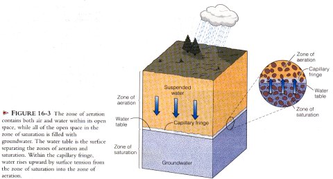
When precipitation occurs over land, some of it evaporates. some is carried away by runoff in streams, and the remainder seeps into the ground. As this water moves down from the surface, some of it adheres to the material that it is moving through and halts its downward progress. This region is thc zone of aeration, and its water is called suspended water. The pore spaces in this zone contain both water and air. Extending irregularly upward a few centimeters to several meters from the zone of saturation below is the capillary fringe. Water moves upward in this region because of surface tension, much as water moves upward through a paper towel.
Beneath the zone of aeration lies the zone of saturation where all of the pore spaces are tilled with groundwater. The base of the zone of saturation varies from place to place, but usually extends to a depth where an impermeable layer is encountered or to a depth where confining pressure closes all open space.
The surface separating the zone of aeration from the underlying zone of saturation is the water table. In general, the configuration of the water table is a subdued replica of the overlying land surface; that is, it has its highest elevations beneath hills and its lowest elevations in valleys. In most arid and semiarid regions. however, the water table is quite flat and is below the level of river valleys.
Several factors contribute to the surface configuration of a regions water table. These include regional differences in the amount of rainfall, permeability, and the rate of groundwater movement. During periods of high rainfall, groundwater tends to rise beneath hills because it cannot flow fast enough into the adjacent it valleys to maintain a level surface. During droughts, the water table falls and tends to flatten out because it is not being replenished.
Groundwater Movement
Groundwater velocity varies greatly and depends on many factors. Velocities ranging from 250 m per day in some extremely permeable material to less than a few centimeters per year in nearly impermeable material have been measured. In most ordinary aquifers, the average velocity of groundwater is a few centimeters per day.
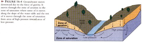
Gravity provides the energy for the downward movement of groundwater. Water entering the ground moves through the zone of aeration to the zone of saturation. When water reaches the water table, it continues to move through the zone of saturation from areas where the water table is high toward areas where it is lower, such as at streams, lakes, or swamps. Only some of the water follows the direct route along the slope of the water table. Most of it takes longer curving paths downward and then enters a stream, lake, or swamp from below. This occurs because groundwater moves from areas of high pressure toward areas of lower pressure within the saturated zone.
Springs, Water Wells, And Artesian Systems
Adding water to the zone of saturation is called recharge, and it causes the water table to rise. Water may be added by natural means, such as rainfall or melting snow, or artificially at recharge basins or wastewater treatment plants. If groundwater is discharged without sufficient replenishment, the water table drops. Groundwater discharges naturally whenever the water table intersects the ground surface as at a spring or along a stream, lake, or swamp. Groundwater can also be discharged artificially by pumping water from wells.
Springs
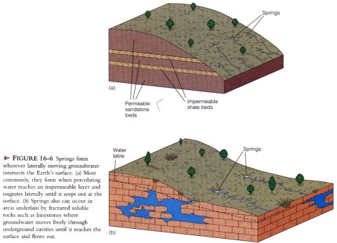
A spring is a place where groundwater flows or seeps out of the ground. Springs have always fascinated people because the water flows out of the ground for no apparent reason and from no readily identifiable source. It is not surprising that springs have long been regarded with superstition and revered for their supposed medicinal value and healing powers. Nevertheless, there is nothing mystical or mysterious about springs.
Although springs can occur under a wide variety of geologic conditions, they all form in basically the same way. When percolating water reaches the water table or an impermeable layer, it flows laterally, and if this flow intersects the Earth’s surface, the water discharges onto the surface as a spring. The Mammoth Cave area in Kentucky, for example, is underlain by fractured limestones that have been enlarged into caves by solution activity. In this geologic environment, springs occur where the fractures and caves intersect the ground surface allowing ground water to exit onto the surface. Springs most commonly occur along valley walls where streams have cut valleys below the regional water table.
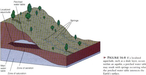
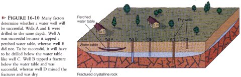
Springs can also develop wherever a perched water table intersects the Earth’s surface. A perched water table may occur wherever a local aquiclude occurs within a larger aquifer, such as a lens of shale Within a sandstone. As water migrates through the zone of aeration, it is stopped by the local aquiclude, and a localized zone of saturation "perched" above the main water table is created. Water moving laterally along the perched water table may intersect the Earth’s surface to produce a spring.
Water Wells
A water well is made by digging or drilling into the zone of saturation. Once the zone of saturation is reached, water percolates into the well and fills it to the level of the water table. Most wells must be pumped to bring the groundwater to the surface.
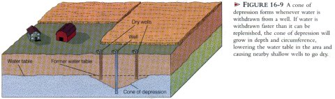
When a well is pumped, the water table in the area around the well is lowered, because water is removed from the aquifer faster than it can be replenished. A cone of depression thus forms around the well. varying in size according to the rate and amount of water being withdrawn. If water is pumped out of a well faster than it can be replaced, the cone of depression grows until the well goes dry. This lowering of the water table normally does not pose a problem for the average domestic well, provided that the well is drilled sufficiently deep into the zone of saturation. The tremendous amounts of water used by industry and irrigation, however, may create a large cone of depression that lowers the water table sufficiently to cause shallow wells in the immediate area to go dry. This situation is not uncommon and frequently results in lawsuits by the owners of the shallow dry wells. Furthermore, lowering of the regional water table is becoming a serious problem in many areas, particularly in the southwestern United States where rapid growth has placed tremendous demands on the groundwater system. Unrestricted withdrawal of groundwater cannot continue indefinitely, and the rising costs and decreasing supply of groundwater should soon limit the growth of this region of the United States.
People in rural areas and those without access to a municipal water system are well aware of the problems of locating an adequate groundwater supply. The distribution and type of rocks present, their porosity and permeability, fracture patterns, and so on are all factors that determine whether a water well will be successful.
Artesian Systems
The word artesian comes from the French town and province of Artois (called Artesium during Roman times) near Calais, where the first European artesian well was drilled in A.D. 1126 and is still flowing today. The term artesian, can be applied to any system in which groundwater is confined and builds up high hydrostatic (fluid) pressure. Water in such a system is able to rise above the level of the aquifer if a well is drilled through the confining layer, thereby reducing the pressure and forcing the water upward. For an artesian system to develop, three geologic conditions must be present (1) the aquifer must be confined above and below by aquicludes to prevent water from escaping; (2) the rock sequence is usually tilted and exposed at the surface, enabling the aquifer to be recharged; and (3) there is sufficient precipitation in the recharge area to keep the aquifer filled.
The elevation of the water table in the recharge are a and the distance of the well from the recharge area determine the height to which artesian water rises in a well. The surface defined by the water table in the recharge area, called the artesian-pressure surface, is indicated by the sloping dashed line in the figure. If there were no friction in the aquifer. well water from an artesian aquifer would rise exactly to the elevation of the artesian-pressure surface. Friction, however. slightly reduces the pressure of the aquifer water and consequently the level to which artesian water rises. This is why the pressure surface slopes.
An artesian well will flow freely at the ground surface only if the wellhead is at an elevation below the artesian pressure surface. In this situation, the water flows out of the well because it rises toward the artesian-pressure surface, which is at a higher elevation than the wellhead. In a nonflowing artesian well, the wellhead is above the artesian-pressure surface, and the water will rise in the well only as high as the artesian-pressure surface.
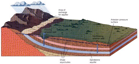
In addition to artesian wells, many artesian springs also exist. Such springs can occur if a fault or fracture intersects the confined aquifer allowing water to rise above the aquifer. Oases in deserts are commonly artesian springs.
Because the geologic conditions necessary for artesian water can occur in a variety of ways, artesian systems are quite common in many areas of the world underlain by sedimentary rocks. One of the best-known artesian systems in the United States underlies South Dakota and extends southward to central Texas. The majority of the artesian water from this system is used for irrigation. The aquifer of this artesian system, the Dakota Sandstone, is recharged where it is exposed along the margins of the Black Hills of South Dakota. The hydrostatic pressure in this system was origin ally great enough to produce free-flowing wells and to operate waterwheels. The extensive use of water for irrigation over the years, has reduced the pressure in many of the wells so that they are no longer free-flowing and the water must be pumped.
Another example of an important artesian system is the Floridan aquifer system. Here Tertiary-aged carbonate rocks are riddled with fractures, caves, and other openings that have been enlarged and interconnected by solution activity. These carbonates are exposed at the surface in the northwestern and central parts of the state where they are recharged, and they dip toward both the Atlantic and Gulf coasts where they are covered by younger sediments. The carbonates are interbedded with shales forming a series of confined aquifers and aquicludes. This artesian system is tapped in the southern part of the state where it is an important source of fresh water and one that is being rapidly depleted.
Groundwater Erosion And Deposition
When rainwater begins seeping into the ground, it immediately starts to react with the minerals it contacts, weathering them chemically. In an area underlain by soluble rock. groundwater is the principal agent of erosion and is responsible for the formation of many major features of the landscape.
Limestone, a common sedimentary rock composed primarily of the mineral calcite (CaCO3) underlies large areas of the Earth’s surface. Although limestone is practically insoluble in pure water, it readily dissolves if a small amount of acid is present. Carbonic acid (H2CO3) is a weak acid that forms when carbon dioxide combines with water (H20 + CO2 = H2CO3). Because the atmosphere contains a small amount of carbon dioxide (0.03%), and carbon dioxide is also produced in soil by the decay of organic matter, most groundwater is slightly acidic. When groundwater percolates through the various openings in limestone, the slightly acidic water readily reacts with the calcite to dissolve the rock by forming soluble calcium bicarbonate, which is carried away in solution.
Sinkholes and Karst Topography
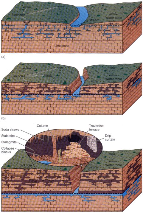
In regions underlain by soluble rock, the ground surface may be pitted with numerous depressions that vary in size and shape. These depressions, called sinkholes or merely sinks, mark areas where the underlying rock has been dissolved. Sinkholes form in one of two ways. The first is when the soluble rock below the soil is dissolved by seeping water. Natural openings in the rock are enlarged and filled in by the overlying soil. As the groundwater continues to dissolve the rock, the soil is eventually removed, leaving depressions that are typically shallow with gently sloping sides.
Sinkholes also form when a cave s roof collapses. usually producing a steep-sided crater. Sinkholes formed in this way are a serious hazard, particularly in populated areas. In regions prone to sinkhole formation, the depth and extent of underlying cave systems must be mapped before any development to ensure that the underlying rocks are thick enough to support planned structures.
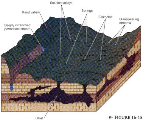
A karst topography is one that has developed largely by groundwater erosion. The name karst is derived from the plateau region of western Slovenia, western Croatia, and northeastern Italy where this type of topography is well developed, In the United States, regions of karst topography include large areas of southwestern Illinois, southern Indiana, Kentucky, Tennessee, northern Missouri, Alabama, and central and northern Florida.
Karst topography is characterized by numerous caves, springs, sinkholes, solution valleys, and disappearing streams. When adjacent sinkholes merge, they form a network of larger, irregular, closed depressions called solution valleys. Disappearing streams are another feature of areas of karst topography. They are so named because they typically flow only a short distance at the surface and then disappear into a sinkhole, The water continues flowing underground through various fractures or caves until it surfaces again at a spring or other stream.
Karst topography can range from the spectacular high-relief landscapes of China to the subdued and pockmarked landforms of Kentucky. What is common to all karst topography, though, is that thick-bedded, readily soluble rock is present at the surface or just below the soil, and enough water is present for solution activity to occur. Karst topography is, therefore, typically restricted to humid and temperate climates. Currently, however, some of the best karst topography can be found in arid and semiarid regions such as Bexar County, Texas, and the Carlsbad Caverns region in New Mexico. The examples of karst topography in these regions are relicts that originally formed when the climate was more humid.
Caves and Cave Deposits
Caves are some of the most spectacular examples of the combined effects of weathering and erosion by groundwater. As groundwater percolates through carbonate rocks, it dissolves and enlarges fractures and openings to form a complex interconnecting system of crevices, caves, caverns, and underground streams. A cave is usually defined as a naturally formed subsurface opening that is generally connected to the surface and is large enough for a person to enter. A cavern is a very large cave or a system of interconnected caves.
More than 17,000 caves are known in the United States. Most of them are small, but some are quite large and spectacular. Some of the more famous caves in the United States are Mammoth Cave, Kentucky; Carlsbad Caverns, New Mexico; Lewis and Clark Caverns, Montana; Wind Cave and Jewel Cave, South Dakota; Lehman Cave, Nevada; and Meramec Caverns, Missouri, which Jesse James and his outlaw band often used as a hideout. While the United States has many famous caves, the deepest known cave in North America is the 536 m deep Arctomys Cave in Mount Robson Provincial Park, British Columbia, Canada.
Caves and caverns form as a result of the dissolution of carbonate rocks by weakly acidic groundwater. Groundwater percolating through the zone of aeration slowly dissolves the carbonate rock and enlarges its fractures and bedding planes. Upon reaching the water table, the groundwater migrates toward the region’s surface streams. As the groundwater moves through the zone of saturation, it continues to dissolve the rock and gradually forms a system of horizontal passageways through which the dissolved rock is carried to the streams. As the surface streams erode deeper valleys, the water table drops in response to the lower elevation of the streams. The water that flowed through the system of horizontal passageways now percolates down to the lower water table where a new system of passageways begins to form. The abandoned channelways now form an interconnecting system of caves and caverns. Caves eventually become unstable and collapse, littering the floor with fallen debris.
When most people think of caves, they think of the seemingly endless variety of colorful and bizarre shaped deposits found in them. Although a great many different types of cave deposits exist, most form in essentially the same manner and are collectively known as dripstone. As water seeps through a cave, some of the dissolved carbon dioxide in the water escapes, and a small amount of calcite is precipitated. In this manner, the various dripstone deposits are formed.
Stalactites are icicle-shaped structures hanging from cave ceilings that form as a result of precipitation from dripping water. With each drop of water, a thin layer of calcite is deposited over the previous layer, forming a cone-shaped projection that grows downward from the ceiling.
The water that drips from a cave’s ceiling also precipitates a small amount of calcite when it hits the floor. As additional calcite is deposited, an upward growing projection called a stalagmite forms. If a stalactite and stalagmite meet, they form a column. Groundwater seeping from a crack in a cave’s ceiling may form a vertical sheet of rock called a drip curtain, while water flowing across a cave’s floor may produce travertine terraces.
Modifications Of The Groundwater System And Their Effects
Groundwater is a valuable natural resource that is rapidly being exploited with little regard to the effects of overuse and misuse. Currently, about 20% of all water used in the United States is groundwater. This percentage is increasing, and unless this resource is used more wisely, sufficient amounts of clean groundwater will not be available in the future. Modifications of the groundwater system may have many consequences including (1) lowering of the water table, which causes wells to dry up; (2) loss of hydrostatic pressure, which causes once free-flowing wells to require pumping; (3) saltwater encroachment; (4) subsidence; and (5) contamination of the groundwater supply.
Lowering of the Water Table
Withdrawing groundwater at a significantly greater rate than it is replaced by either natural or artificial recharge can have serious effects. For example, the High Plains aquifer is one of the most important aquifers in the United States. Underlying most of Nebraska, large parts of Colorado and Kansas, portions of South Dakota, Wyoming, and New Mexico, as well as the panhandle regions of Oklahoma and Texas, it accounts for approximately 30% of the groundwater used for irrigation in the United States. Irrigation from the High Plains aquifer is largely responsible for the high agricultural productivity of this region, where a significant percentage of the nation’s corn, cotton, and wheat is grown, and half of U.S. beef cattle are raised. Large areas of land (more than 14 million acres) are currently irrigated with water pumped from the High Plains aquifer. Irrigation is popular because yields from irrigated lands can be triple what they would be without irrigation.
While the High Plains aquifer has contributed to the high productivity of the region, it cannot continue providing the quantities of water that it has in the past. In some parts of the High Plains, from 2 to 100 times more water is being pumped annually than is being recharged. Consequently, water is being removed from the aquifer faster than it is being replenished, causing the water table to drop significantly in many areas.
What will happen to this region’s economy if long-term withdrawal of water from the High Plains aquifer greatly exceeds its recharge rate such that it can no longer supply the quantities of water necessary for irrigation? Solutions range from going back to farming without irrigation to diverting water from other regions such as the Great Lakes. Farming without irrigation would result in greatly decreased yields and higher costs and prices for agricultural products. while the diversion of water from elsewhere would cost billions of dollars and the price of agricultural products would still rise.
Saltwater Incursion
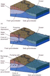
The excessive pumping of groundwater in coastal areas can result in saltwater incursion such as occurred on Long Island, New York, during the 1960's. Along coastlines where permeable rocks or sediments are in contact with the ocean, the fresh groundwater, being less dense than seawater, forms a lens-shaped body above the underlying salt water (a). The weight of the fresh water exerts pressure on the underlying salt water. As long as rates of recharge equal rates of withdrawal, the contact between the fresh groundwater and the seawater will remain the same. If excessive pumping occurs, however, a deep cone of depression forms in the fresh groundwater (b). Because some of the pressure from the overlying fresh water has been removed, salt water migrates upward to fill the pore space that formerly contained fresh water. When this occurs, wells become contaminated with salt water and remain contaminated until recharge by fresh water restores the former level of the fresh groundwater water table.
Saltwater incursion is a major problem in many rapidly growing coastal communities. As the population in these areas grows, greater demand for groundwater creates an even greater imbalance between recharge and withdrawal.
Not only is saltwater incursion a major concern for some coastal communities, it is also becoming a problem in the Salinas Valley, California, which produces fruits and vegetables valued at about $1.7 billion annually. Here, in an area encompassing about 160,000 acres of rich farmland 161 km south of San Francisco, saltwater incursion caused by over-pumping of several shallow-water aquifers is threatening the groundwater supply that is used for irrigation. Because of the drought in recent years and increased domestic needs caused by a burgeoning population, over-pumping has resulted in increased seepage of salt water into the groundwater system such that large portions of some of the aquifers are now too salty even for irrigation. At some locations in the Salinas Valley, seawater has migrated more than 11 km inland during the past 13 years. Left unchecked, the farmlands of the valley could become too salty to support most agriculture.
Farmers currently use 85% of all the groundwater removed, and unless some curbs are placed on the amount removed for irrigation, saltwater contamination of the shallow aquifers will continue to accelerate until the water is too salty for irrigation. Uncontaminated deep aquifers could be tapped to replace the contaminated shallow groundwater. but doing so is too expensive for most farmers and small towns.
To counteract the effects of saltwater incursion, recharge wells are often drilled to pump water back into the groundwater system. Recharge ponds that allow large quantities of fresh surface water to infiltrate the groundwater supply may also be constructed. Both of these methods are successfully used on Long Island, which has had a saltwater incursion problem for several decades.
Subsidence
As excessive amounts of groundwater are withdrawn from poorly consolidated sediments and sedimentary rocks. the water pressure between grains is reduced, and the weight of the overlying materials causes the grains to pack closer together, resulting in subsidence of the ground. As more and more groundwater is pumped to meet the increasing needs of agriculture, industry, and population growth, subsidence is becoming more prevalent.
The San Joaquin Valley of California is a major agricultural region that relies largely on groundwater for irrigation. Between 1925 and 1975, groundwater withdrawals in parts of the valley caused subsidence of almost 9 in. Other examples of subsidence in the United States include New Orleans, Louisiana, and Houston, Texas, both of which have subsided more than 2 m, and Las Vegas. Nevada, which has subsided 8.5 m.Elsewhere in the world, the tilt of the Leaning Tower of Pisa is partly due to groundwater withdrawal. The tower started tilting soon after construction began in 1173 because of differential compaction of the foundation. During the 1960's, the city of Pisa withdrew ever larger amounts of groundwater, causing the ground to subside further; as a result, the tilt of the tower increased until it was considered in danger of falling over. Strict control of groundwater withdrawal and stabilization of the foundation have reduced the amount of tilting to about 1 mm per year, thus ensuring that the tower should stand for several more centuries.
A spectacular example of subsidence occurred in Mexico City, which is built on a former lake bed. As groundwater is removed for the ever increasing needs of the city, the fine-grained lake sediments are compacting. and Mexico City is slowly and unevenly subsiding. Its opera house has settled more than 3 m, and half of the first floor is now below ground level. Other parts of the city have subsided more than 6 m, creating similar problems for other structures.
The extraction of oil can also cause subsidence. Long Beach, California, has subsided 9 m as a result of 34 years of oil production. More than $100 million of damage was done to the pumping, transportation, and harbor facilities in this area because of subsidence and encroachment of the sea. Once water was pumped back into the oil reservoir, subsidence virtually stopped.
Groundwater Contamination
A major problem facing our society is the safe disposal of the numerous pollutant by-products of an industrialized economy. We are becoming increasingly aware that our streams, lakes, and oceans are not unlimited reservoirs for waste, and that we must find new safe ways to dispose of pollutants.
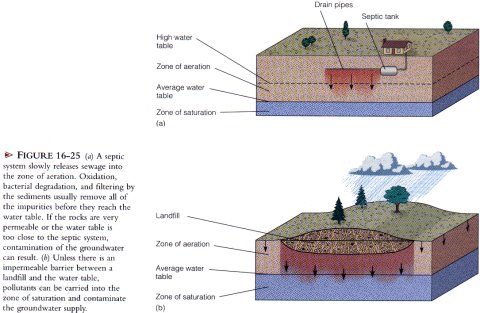
The most common sources of groundwater contamination are sewage, landfills, toxic waste disposal sites, and agriculture. Once pollutants get into the groundwater system, they will spread wherever ground water travels, which can make containment of the contamination difficult. Furthermore, because groundwater moves very slowly, it takes a very long time to cleanse a groundwater reservoir once it has become contaminated.In many areas, septic tanks are the most common way of disposing of sewage. A septic tank slowly releases sewage into the ground where it is decomposed by oxidation and microorganisms and filtered by the sediment as it percolates through the zone of aeration. In most situations, by the time the water from the sewage reaches the zone of saturation, it has been cleansed of any impurities and is sate to use. If the water table is very close to the surface or if the rocks are very permeable, water entering the zone of saturation may still be contaminated and unfit to use.
Landfills are also potential sources of groundwater contamination. Not only does liquid waste seep into the ground, but rainwater also carries dissolved chemicals and other pollutants downward into the groundwater reservoir. Unless the landfill is carefully designed and lined below by an impermeable layer such as clay, many toxic and cancer-causing compounds will find their way into the groundwater system. Paints, solvents, cleansers, pesticides, and battery acid are just a few of the toxic household items that end up in landfills and can pollute the groundwater supply.
Toxic waste sites where dangerous chemicals are either buried or pumped underground are an increasing source of groundwater contamination, The United States alone must dispose of several thousand metric tons of hazardous chemical waste per year. Unfortunately, much of this waste has been, and still is being, improperly dumped and is contaminating the surface water, soil, and groundwater.
Hot Springs And Geysers
The subsurface rocks in regions of recent volcanic activity usually stay hot for thousands of years. Groundwater percolating through these rocks is heated and, if returned to the surface, forms hot springs or geysers. Yellowstone National Park in the United States, Rotorua, New Zealand, and Iceland are all famous for their hot springs and geysers. They are all sites of recent volcanism, and consequently their subsurface rocks and groundwater are very hot.
A hot spring (also called a thermal spring or warm spring) is a spring in which the water temperature is warmer than the temperature of the human body (37degrees C). Some hot springs, though, are much hotter, with temperatures ranging up to the boiling point in many instances, Of the approximately 1,100 known hot springs in the United States, more than 1,000 are in the Far West, while the rest are in the Black Hills of South Dakota, the Ouachita region of Arkansas, Georgia, and the Appalachian region.
Hot springs are also common in other parts of the world. One of the most famous is at Bath, England, where shortly after the Roman conquest of Britain in AD. 43, numerous bathhouses and a temple were built around the hot springs.
The heat for most hot springs comes from magma or cooling igneous rocks. The geologically recent igneous activity in the western United States accounts for the large number of hot springs in that region. The water in some hot springs, however, is circulated deep into the Earth, where it is warmed by the normal increase in temperature, the geothermal gradient. For example, the spring water of Warm Springs, Georgia, is heated in this manner. This hot spring was a health and bathing resort long before the Civil War; later, with the establishment of the Georgia Warm Springs Foundation, it was used to help treat polio victims.
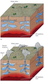
Geysers are hot springs that intermittently eject hot water and steam with tremendous force. The word comes from the Icelandic geysir, which means to gush or rush forth. One of the most famous geysers in the world is Old Faithful in Yellowstone National Park in Wyoming. With a thunderous roar, it erupts a column of hot water and steam every 30 to 90 minutes. Other well-known geyser areas are found in Iceland and New Zealand.
Geysers are the surface expression of an extensive underground system of interconnected fractures within hot igneous rocks. Groundwater percolating clown into the network of fractures is heated as it comes into contact with the hot rocks. Because the water near the bottom of the fracture system is under greater pressure than that near the top, it must be heated to a higher temperature before it will boil. Thus, when the deeper water is heated to very near the boiling point, a slight rise in temperature or a drop in pressure, such as from escaping gas, will cause it to change instantly to steam. The expanding steam quickly pushes the water above it out of the ground and into the air, thereby producing a geyser eruption. After the eruption, relatively cool groundwater starts to seep back into the fracture system where it is heated to near its boiling temperature and the eruption cycle begins again. Such a process explains how geysers can erupt with some regularity.
Hot spring and geyser water typically contains large quantities of dissolved minerals because most minerals dissolve more rapidly in warm water than in cold water. Due to this high mineral content, the waters of many hot springs are believed by some to have medicinal properties. Numerous spas and bathhouses have been built at hot springs throughout the world to take advantage of these supposed healing properties.
When the highly mineralized water of hot springs or geysers cools at the surface, some of the material in solution is precipitated, forming various types of deposits. The amount and type of precipitated mineral depend on the solubility and composition of the material through which the groundwater flows. If the groundwater contains dissolved calcium carbonate (CaCO3), then travertine or calcareous tufa (both of which are varieties of limestone) are precipitated. Spectacular examples of hot spring travertine deposit are found at Pamukhale in Turkey and at Mammoth Hot Springs in Yellowstone National Park. Groundwater containing dissolved silica will, upon reaching the surface, precipitate a soft, white, hydrated mineral called siliceous sinter or geyserite, which can accumulate around a geyser’s opening.
Geothermal Energy
Energy harnessed from steam and hot water trapped within the Earth’s crust is called geothermal energy. It is a desirable and relatively nonpolluting alternate form of energy. Approximately 1 to 2% of the world’s current energy needs could be met by geothermal energy. In those areas where it is plentiful, geothermal energy can supply most, if not all, of the energy needs, sometimes at a fraction of the cost of other types of energy. Unfortunately, many of the areas of geothermal power are remote and far from population centers. Furthermore, many are in national parks, such as Yellowstone National Park, and thus cannot be exploited. Some of the countries currently using geothermal energy in one form or another include Iceland. the United States, Mexico, Italy, New Zealand, Japan, the Philippines, and Indonesia.
Geothermal energy has been successfully used in Iceland since 1928. In Reykjavik, Iceland’s capital, steam and hot water from wells drilled in geothermal areas are pumped into buildings for heating and hot water. Fruits and vegetables are grown year-round in hothouses heated from geothermal wells. Direct heating in this manner is significantly cheaper than fuel oil or electrical heating and much cleaner.
The city of Rotorua in New Zealand is world famous for its volcanoes, hot springs, geysers, and geothermal fields. Since the first well was sunk in the 1930's, more than 800 wells have been drilled to tap the hot water and steam below. Geothermal energy in Rotorua is used in a variety of ways, including home, commercial, and greenhouse heating.
In the United States, the first commercial geothermal electrical generating plant was built in 1960 at The Geysers, about 120 km north of San Francisco, California. Here, wells were drilled into the numerous near-vertical fractures underlying the region. As pressure on the rising groundwater decreases, the water changes to steam that is piped directly to electricity generating turbines. The present electrical generating capacity at The Geysers is about 2,000 megawatts, which is enough to supply about two-thirds of the electrical needs of the San Francisco Bay area.
As oil reserves decline, geothermal energy is becoming an attractive alternative, particularly in parts of the western United States, such as the Salton Sea area of southern California, where geothermal exploration and development have begun. While geothermally generated electricity is a generally clean source of power, it can also be expensive because most geothermal waters are acidic and very corrosive. Consequently, the turbines must either be built of expensive corrosion-resistant alloy metals or frequently replaced. Furthermore, geothermal power is not inexhaustible. The steam and hot water removed for geothermal power cannot be easily replaced, and eventually pressure in the wells drops until the geothermal field must be abandoned.