Deformation, Mountain Building, and The Evolution of Continents
Deformed rocks are a manifestation of the dynamic nature of the Earth. Many ancient rocks are fractured or highly contorted, clearly indicating that forces within the Earth caused deformation during the past. Such deformation is not restricted to the past, however; seismic activity and continuing deformation at convergent, divergent, and transform plate boundaries indicate that deforming forces remain active.
Mountains can form in a variety of ways, some of which involve little or no deformation, but in most mountains the rocks have been complexly deformed by compressive forces at convergent plate boundaries. The Alps of Europe, the Appalachians of North America, the Himalayas of Asia, and many other owe their existence, and in some cases continuing evolution, to plate convergence. In short, deformation and mountain building are closely related phenomena.
Deformation
Fractured and contorted rock are said to be deformed; that is, their original shape or volume or both have been altered by stress, which is the result of force applied to a given area of rock. If the intensity of the stress is greater than the internal strength of the rock, it will undergo strain, which is deformation caused by stress.
Three types of stress are recognized: compression, tension, and shear. Compression results when rocks are squeezed or compressed by external forces directed toward one another. Rock layers subjected to compression are commonly shortened in the direction of stress by folding or faulting. Tension results from forces acting in opposite directions along the same line. Such stress tends to lengthen rocks or pull them apart. In shear stress, forces act parallel to one another but in opposite directions, resulting in deformation by displacement of adjacent layers along closely spaced planes.
Strain is characterized as elastic if a deformed object returns to its original shape when the stresses are relaxed. Most rocks are not very elastic, but the Earth's crust responds by elastic strain when it is loaded by glacial ice and is depressed into the mantle.
When stress is applied to rocks, they respond first by elastic strain, but when strained beyond their elastic limit, they cannot recover their original shape. Such rocks deform by plastic strain as when they are folded, or they behave as brittle solids and are fractured.
Many rocks show the effects of plastic deformation that must have occurred deep within the Earth's crust where the temperature and pressure are high. The behavior of rock materials under these conditions is very different from their behavior near the surface. At or near the surface, they behave as brittle solids, whereas under conditions of high temperature and high pressure, they more commonly deform plastically rather than fracture. The foci of most earthquakes are at depths of less than 30km, indicating that deformation by fracturing becomes increasingly difficult with depth, and no fracturing is known to occur at depths greater than 700km.
The type of strain that occurs depends on the kind of stress applied, the amount of pressure, the temperature, the rock type, and the length of time the rock is subjected to the stress. A small stress applied over a long period of time, will cause plastic deformation. By contrast, a large stress applied rapidly to the same object, as when it is struck by a hammer, will probably result in fracture. Rock type is important because not all rocks respond to stress in the same way. Rocks are considered to be either ductile or brittle depending on the amount of plastic strain before fracture, whereas ductile rocks exhibit a great deal.
Strike and Dip
According to the principle of original horizontally, when sediments are deposited, they accumulate in nearly horizontal layers. Thus, sedimentary rock layers that are steeply inclined must have been tilted following deposition and lithification. Some igneous rocks, especially ash falls and many lava flows, also form nearly horizontal layers. To describe the orientation of deformed rock layers, geologists use the concept of strike and dip.
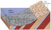
Strike is the direction of a line formed by the intersection of a horizontal plane with an inclined plane, such as a rock layer. Dip is a measure of the maximum angular deviation of an inclined plane from horizontal, so it must be measured perpendicular to the strike direction.
Geologic maps indicate strike and dip by using a long line oriented in the strike direction and a short line perpendicular to the strike line and pointing in the dip direction. The number adjacent to the strike and dip symbol indicates the dip angle.
Folds
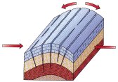
If you place your hands on a tablecloth and move them toward one another, the tablecloth is deformed by compression into a series of up- and down-arched folds. Similarly, rock layers within the Earth’s crust commonly respond to compression by folding. Unlike the tablecloth, though, Folding in rock layers is permanent; that is, the rocks have been strained plastically so once folded, they stay folded. Most folding probably occurs deep within the crust where rocks are ductile.
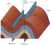
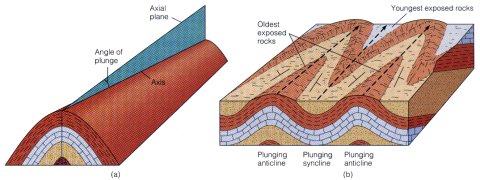
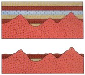
Monoclines, Anticlines, and Synclines. A monocline is a simple bend or flexure in otherwise horizontal or uniformily dipping rock layers. An anticline is an up-arched fold, while a syncline is a down-arched fold . Both anticlines and synclines have an axial plane that divides them into halves each half is a limb. Because folds most commonly occur as a series of anticlines alternating with synclines, a limb is generally shared by an anticline and an adjacent syncline.
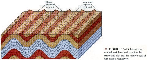
It is important to remember that anticlines and synclines are defined by the orientation of rock layers and not by the configuration of the Earth’s surface. Thus, folds may or may not correspond to mountains and valleys and may, in fact, underlie areas where the Earth’s surface is rather flat. Indeed, folds are commonly exposed to view in areas that have been deeply eroded. But even where folds have been eroded, anticlines and synclines can easily be distinguished from each other by strike and dip and by the relative ages of the folded rocks. In an eroded anticline, each limb dips outward or away from the center of the fold, where the oldest rocks are. In eroded synclines, on the other hand, each limb dips inward toward the fold’s center, and the youngest rocks coincide with the center of the fold
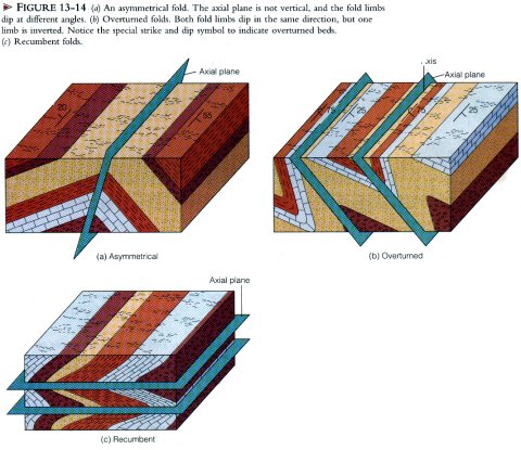
Thus far, we have described symmetrical, or upright, folds in which the axial plane is vertical, and each fold limb dips at the same angle. If the axial plane is inclined, however, the limbs dip at different angles, and the fold is characterized as asymmetrical. In an overturned fold, both limbs dip in the same direction. In other words, one fold limb has been rotated more than 9O degrees from its original position so that it is now upside down. Folds in which the axial plane is horizontal are referred to as recumbent. Overturned and recumbent folds are particularly common in mountain ranges that formed by compression at convergent plate boundaries.
Plunging Folds. Folds may be further characterized as non-plunging or plunging. In the former, the fold axis, a line formed by the intersection of the axial plane with the folded beds, is horizontal. However, it is much more common for the axis to be inclined so that it appears to plunge beneath the surrounding rocks; folds possessing an inclined axis are plunging folds. To differentiate plunging anticlines from plunging synclines, geologists use exactly the same criteria used for non-plunging folds: that is, all rocks dip away from the fold axis in plunging anticlines, whereas in plunging synclines all rocks dip inward toward the axis. The oldest exposed rocks are in the center of an eroded plunging anticline, whereas the youngest exposed rocks are in the center of an eroded plunging syncline.
Anticlines form one type of structural trap for petroleum and natural gas. As a matter of fact, most of the world’s petroleum production comes from anticline traps, although several other types are also important. Accordingly, geologists are particularly interested in correctly identifying the geologic structures in areas of potential petroleum and natural gas production.
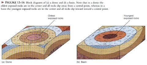
Domes and Basins. Domes and basins are the circular to oval equivalents of anticlines and synclines, respectively. They tend to be rather equidimensional whereas anticlines and synclines are elongate structures. Essentially the same criteria used in recognizing anticlines and synclines are used to differentiate domes and basins. In an eroded dome, the oldest exposed rocks are in the center whereas in a basin the opposite is true. All of the rocks in a dome dip away from a central point (as opposed to dipping away from a fold axis, which is a line). By contrast, all the rocks in a basin dip inward toward a central point.
Some domes and basins are small structures that are easily recognized by their surface exposure patterns, but many are so large that they can be visualized only on geologic maps or aerial photographs. Many of these large-scale structures formed in the continental interior, not by compression, but as a result of vertical uplift of parts of the Earth’s crust with little additional folding and faulting.
The Black Hills of South Dakota are a large eroded dome with a core of ancient rocks surrounded by progressively younger rocks. The rocks dip outward rather uniformly from the Black Hills, which have been uplifted so that they now stand more than 2,000m above the adjacent plains. One of the best-known large basins in the United States is the Michigan basin. Most of the Michigan basin is buried beneath younger rocks so it is not directly observable at the surface. Nevertheless, strike and dip of exposed rocks near the basin margin and thousands of drill holes for oil and gas clearly show that the rock layers beneath the surface are deformed into a large structural basin.
Joints
Joints are fractures along which no movement has occurred or movement is perpendicular to the fracture surface. In other words, a joint may open up. but the rocks on opposite sides of the fracture show no movement parallel to the fracture. This lack of movement parallel to joint surfaces is what distinguishes joints from faults, which do show movement parallel to the fracture surface. Coal miners originally used the term "joint" long ago for cracks in rock that appeared to be surfaces where adjacent blocks were "joined" together.
Joints are the commonest structures in rocks. Recall that rocks near the Earth’s surface are brittle and therefore commonly fail by fracturing when subjected to stresses. Hence nearly all near-surface rocks are jointed to some degree. Joints can form in response to compression, tension, and shearing. They vary from minute fractures to those of regional extent and are often arranged in parallel or nearly parallel sets. It is common for a region to have two or perhaps three prominent sets. Regional mapping reveals that joints and joint sets are usually related to other geologic structures such as faults and large folds. Weathering and erosion of jointed rocks in Utah have produced the spectacular scenery of Arches National Park.
It may seem odd that joints, which indicate brittle behavior, are so common in folded rocks that have been deformed plastically. Of course, some joints form before folding when the rocks are near the surface where they are brittle. But even rocks that exhibit considerable plastic deformation, such as occurs during folding, can be fractured. The crest of an anticline provides a good example of how this might occur. Although anticlines are produced by compression, the rock layers are arched such that tension occurs perpendicular to fold crests, and joints form parallel to the long axis of the fold in the upper part of a folded layer.
We have already discussed two other types of joints in earlier chapters: columnar joints and sheet jointing. Columnar joints form in some lava flows and in some plutons. Cooling magma contracts, it develops tensional stresses that form polygonal fracture patterns. Sheet jointing forms in response to pressure release.
Faults
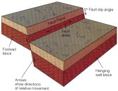
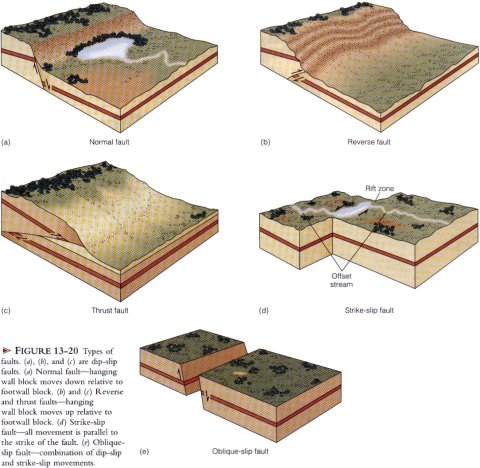
A fault is a fracture along which blocks on opposite sides of the fracture move parallel with the fracture surface, which is a fault plane. One of the manifestations of faulting is a fault scarp, or a cliff formed as a result of vertical movement. Fault scarps are usually quickly modified by erosion and obscured. When rocks on opposite sides of a fault plane move past one another, they may be scratched and polished by friction along the fault plane or crushed and shattered into angular blocks forming a fault breccia.
To differentiate among the various types of faults, one must be able to identify hanging wall and footwall blocks and understand the concept of relative movement. Geologists refer to relative movement because one usually cannot tell which block actually moved or if both blocks moved.
Like rock layers, fault planes can also be characterized by their strike and dip. Two basic types of faults are recognized according to whether the blocks on opposite sides of the fault plane have moved parallel to the direction of dip or along the direction of strike.
Dip-Slip Faults
In dip-slip faults, all movement is parallel with the dip of the fault plane. In other words, all movement is such that one block moves up or down relative to the block on the opposite side of the fault plane. Two types of dip-slip faults are recognized: normal and reverse.
Normal faults are caused by tensional stresses, such as those that occur when the Earth’s crust is stretched and thinned by rifting. The mountain ranges in the Basin and Range Province, a large area in the western United States and northern Mexico, are bounded on one or both sides by large normal faults. A normal fault is present along the east side of the Sierra Nevada in California where uplift of the block west of the fault has elevated the mountains more than 3,000 m above the lowlands to the east.
The second type of dip-slip fault is a reverse fault. A reverse fault involving a fault plane with a dip of less than 430 is a thrust fault. Reverse and thrust faults are easily distinguished from normal faults because the hanging wall block moves up relative to the footwall block.
Reverse and thrust faults are caused by compression. Many large faults of these varieties are present in mountain ranges that formed by compression at convergent plate boundaries. A well-known thrust fault is the Lewis overthrust of Montana, where a large slab of Precambrian-aged rocks moved at least 75 km eastward on the fault and now rests upon much younger rock of Cretaceous age.
Strike-Slip Faults. Shearing forces are responsible for strike-slip faulting, a type of faulting involving horizontal movement in which blocks on opposite sides of a fault plane slide sideways past one another. In other words, all movement is in the direction of the fault plane’s strike.
One of the best-known strike-slip faults is the San Andreas fault of California. Movement on this fault caused the October 29, 1989 earthquake that damaged much of Oakland. San Francisco, and several communities to the south and resulted in a 10-day delay of the World Series.
Strike-slip faults can be characterized as right-lateral or left-lateral, depending on the apparent direction of offset.
Oblique-Slip Faults. It is possible for movement on a fault to show components of both dip-slip and strike-slip. Strike-slip movement may be accompanied by a dip-slip component giving rise to a combined movement that includes left-lateral and reverse, or right-lateral and normal. Faults having components of both dip-slip and strike-slip movement are oblique-slip faults.
Various faults as well as folds and joints are commonly depicted on geologic maps. Geologists, engineers, city and regional planners, and people in various other professions use these maps for numerous purposes.
Mountains
The term mountain refers to any area of land that stands significantly higher than the surrounding country. Some mountains are single, isolated peaks, but much more commonly they are parts of a linear association of peaks and/or ridges called mountain ranges that are related in age and origin. A mountain system is a mountainous region consisting of several or many mountain ranges such as the Rocky Mountains and Appalachians. Mountain systems are complex linear zones of intense deformation and crustal thickening characterized by many of the geologic structures previously discussed.
Mountain systems are indeed impressive features and represent the effects of dynamic processes operating within the Earth. The forces necessary to elevate the Himalayas of Asia to nearly 9 km above sea level are difficult to comprehend, yet when compared with the size of the Earth, even the loftiest mountains are very small features. In fact, the greatest difference in elevation on Earth is about 20 km; if we depicted this to scale on a globe 1 m in diameter, its relief would be less than 2 mm. From the human perspective, however, mountain systems are large-scale manifestations of tremendous forces that have produced folded, faulted, and thickened parts of the crust. Furthermore, in some mountain systems, such as the Andes of South America and the Himalayas of Asia, the mountain-building processes remain active today.
Types of Mountains
Mountainous topography can develop in a variety of ways, some of which involve little or no deformation of the Earth’s crust. A single volcanic mountain can develop over a hot spot, but more commonly a series of volcanoes develops as a plate moves over the hot spot, as in the case of the Hawaiian Islands.
Mountainous topography also forms where the crust has been intruded by batholiths that are subsequently uplifted and eroded. The Sweet-grass Hills of northern Montana consist of resistant plutonic rocks exposed following uplift and erosion of the softer overlying sediment rocks.
Block-faulting is yet another way mountains are formed. Block-faulting involves movement on normal faults so that one or more blocks are elevated relative to adjacent areas. A classic example is the large-scale block-faulting currently occurring in the Basin and Range Province of the western United States, a large area centered on Nevada but extending into several adjacent states and northern Mexico. In the Basin and Range Province, the Earth's crust is being stretched in an east-west direction and tensional stresses produce north-south oriented, range- bounding faults. Differential movement on these faults has yielded uplifted blocks called horsts and down-dropped blocks called grabens. Horsts and grabens are bounded on both sides by parallel normal faults. Erosion of the horsts has yielded the mountainous topography now present, and the grabens have filled with sediments eroded from the horsts.
The processes discussed above can certainly yield mountains. However, the truly large mountain systems of the continents, such as the Alps of Europe and the Appalachians in North America, were produced by compression along convergent plate margins.
Mountain Building: Orogenesis
During an episode of mountain building, termed an orogeny, intense deformation occurs, generally accompanied by metamorphism and the emplacement of plutons, especially batholiths. Orogenesis, the processes whereby mountains form, is still not fully understood, but it is known to be related to plate movements. In fact, the advent of plate tectonic theory has completely changed the way geologists view the origin of mountain systems.
Any theory accounting for orogenesis must adequately explain the characteristics of mountain systems such as their geometry and location: they tend to be long and narrow and to be located at or near plate margins. Mountain systems also show intense deformation, especially compression-induced overturned and recumbent folds and reverse and thrust faults. Furthermore, the deeper, interior parts or cores of mountain systems are characterized by granitic plutons and regional metamorphism. The presence of deformed shallow and deep marine sedimentary rocks that have been elevated far above sea level is another feature.
Plate Boundaries and Orogenesis
Most of the Earth’s geologically recent and present--day orogenic activity is concentrated in two major zones or belts: the Alpine-Himalayan orogenic belt and the circum-Pacific orogenic belt. Both belts consist of a number of smaller segments known as orogens, many of which are areas of active orogenesis today.
Most orogenesis occurs in response to compressive stresses at convergent plate boundaries. Three varieties of convergent plate boundaries are recognized: oceanic-oceanic, oceanic-continental and continental-continental.
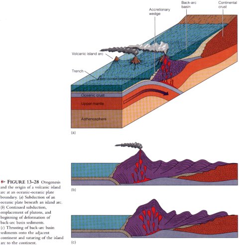
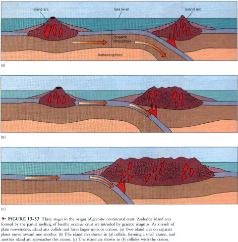
Orogenesis at Oceanic-Oceanic Plate Boundaries. Orogenies occurring where oceanic lithosphere is subducted beneath oceanic lithosphere are characterized by the formation of a volcanic island arc and by deformation, igneous activity, and metamorphism. The subducted plate forms the outer wall of an oceanic trench, and the inner wall of the trench consists of a subduction complex or accretionary wedge composed of wedge shaped slices of highly folded and faulted marine sedimentary rocks and oceanic lithosphere scraped from the descending plate. This subduction complex is elevated as a result of uplift along faults as subduction continues. In addition, plate convergence results in low- temperature, high-pressure metamorphism characteristic of the blueschist facies.
Deformation also occurs in the island arc system where it is caused largely by the emplacement of plutons of intermediate and felsic composition, and many rocks. show evidence of high temperature, low-pressure metamorphism. As a result, the overriding oceanic plate is thickened as it is intruded by plutons and becomes more continental. The overall effect of island arc orogenesis is the origin of two more-or-less parallel orogenic belts consisting of a deformed volcanic island arc underlain by batholiths and a seaward belt of deformed trench rocks. The Japanese Islands are a good example of this type of deformation.
In the hack-arc basin, volcanic rocks derived from the island arc and sediments eroded from the island arc and the adjacent continent are also deformed as the plates continue to converge. They are intensely folded and displaced toward the adjacent continent along low-angle thrust faults. Eventually, the entire island arc complex with its core of metamorphic and plutonic rocks is fused to the edge of the continent, and the back-arc basin sediments are thrust onto the continent and form a thick stack of thrust sheets.
Orogenesis at Oceanic-Continental Plate Boundaries.
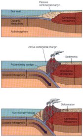
Several mountain systems such as the Alps of Europe and the Andes of South America formed at oceanic-continental plate boundaries where oceanic lithosphere is subducted. The Andes of western South America are perhaps the best example of such continuing orogeny. Among the ranges of the Andes are the highest mountain peaks in the Americas; 49 of these peaks are more than 6,000 m high. The Andes also include many active volcanoes, and the western part of South America is an extremely active segment of the circum-Pacific earthquake belt. Furthermore, one of the Earth’s great oceanic trench systems, the Peru-Chile Trench, lies just off the west coast.
Prior to 200 million years ago, the western margin of South America was a passive continental margin, where sediments accumulated on the continental shelf, slope, and rise much as they currently do along the east coast of North America. When Pangaea hegan fragmenting in response to rifting along what is now the Mid-Atlantic Ridge, the South American plate moved westward, and eastward-moving oceanic lithosphere began subducting beneath the continent. What had been a passive continental margin was now an active one.
As suhduction proceeded, rocks of the continental margin and trench were folded and faulted and are now part of an accretionary wedge along the west coast of South America. Accretionary wedges here and elsewhere commonly contain fragments of oceanic crust and upper mantle called ophiolites. A well-known accretionary wedge in North America is the Franciscan Group, a 7,000 m thick, complex assemblage of various rock types exposed in the Coast Ranges of California.
Subduction also resulted in partial melting of the descending plate, producing an andesitic volcanic arc of composite volcanoes at the edge of the continent. More viscous felsic magmas, mostly of granitic composition, were emplaced as large plutons beneath the volcanic arc. The coastal batholith of Peru, for example, consists of perhaps 800 individual plutons that were emplaced over several tens of millions of years.
As a result of the events just described, the Andes Mountains consist of a central core of granitic rocks capped by andesitic volcanoes. To the west of this central core along the coast are the deformed rocks of the accretionary wedge. And to the east of the central core are sedimentary rocks that have been intensely folded and thrust eastward onto the continent. Present day subduction, volcanism, and seismicity along Sotith America's west coast indicate that the Andes Mountains are still actively funning.
Orogenesis at Continental-Continental Plate Boundaries.
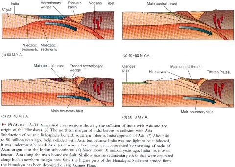
The Himalayas of Asia began forming When India collided with Asia about 40 to 30 million years ago. Prior to that tune, India was far south of Asia and separated from it by an ocean basin. As the Indian plate moved northward, a subduction zone formed along the southern margin of Asia where oceanic lithosphere was consumed. Partial melting generated magma, which rose to form a volcanic arc, and large granite plutons were emplaced into what is now Tibet. At this stage, the activity along Asia’s southern margin was similar to what is now occurring along the west coast of South America.
The ocean separating India from Asia continued to close, and India eventually collided with Asia. As a result, two continental plates became welded, or sutured, together. Thus, the Himalayas are now located within a continent rather than along a continental margin. The exact time of India’s collision with Asia is uncertain, but between 40 and 50 million years ago, India’s rate of northward drift decreased abruptly from 15 to 20 cm per year to about 5 cm per year. Because continental lithosphere is not dense enough to be subducted, this decrease in rate seems to mark the time of collision and India’s resistance to subduction. Consequently, India’s leading margin was thrust beneath Asia, causing crustal thickening, thrusting, and uplift. Sedimentary rocks that had been deposited in the sea south of Asia were thrust northward, and two major thrust faults carried rocks of Asian origin onto the Indian plate. Rocks deposited in the shallow seas along India’s northern margin now form the higher parts of the Himalayas.
As the Himalayas were uplifted, they were also eroded, but at a rate insufficient to match the uplift. Much of the debris shed from the rising mountains was transported to the south and deposited as a vast blanket of sediment on the Ganges Plain and as huge submarine fans in the Arabian Sea and the Bay of Bengal. Since its collision with Asia, India has been thrust about 2,000 km beneath Asia. Currently, India is moving north at a rate of about 5 cm per year.
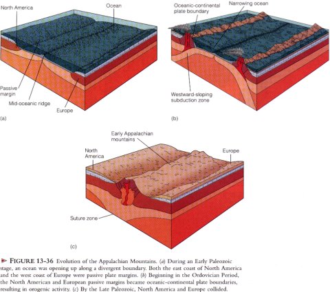
A number of other mountain systems also formed as a result of collisions between two continental plates. The Urals in Russia and the Appalachians of North America formed by such collisions. Also, west of the Himalayas, the Arabian plate is colliding with Asia along the Zagros Mountains of Iran.
Microplate Tectonics And Mountain Building
In the preceding sections, we discussed orogenies along convergent plate boundaries resulting in continental accretion. Much of the material accreted to continents during these events is simply eroded older continental crust, but a significant amount of new material is added to continents as well--igneous rocks that formed as a consequence of subduction and partial melting and the suturing of an island arc to a continent, for example. Although subduction is the predominant influence on tectonic history in many regions of orogenesis, other processes are also involved in mountain building and continental accretion, especially the accretion of microplates.
During the late 1 970's and 1 980's, geologists discovered that portions of many mountain systems are composed of small accreted lithospherie blocks that are clearly of foreign origin. These microplates differ completely in their fossil content, structural trends, and paleomagnetic properties from the rocks of the surrounding mountain system. In fact, these microplates are so different from adjacent rocks that most geologists think they formed elsewhere and were carried great distances as parts of other plates until they collided with other microplates or continents.
Geologic evidence indicates that more than 25% of the entire Pacific coast from Alaska to Baja California consists of accreted microplates. The accreting microplates are composed of volcanic island arcs, oceanic ridges, seamounts, and small fragments of continents that were scraped off and accreted to the continent’s margin as the oceanic plate with which they were carried was subducted under the continent. It is estimated that more than 100 different-sized microplates have been added to the western margin of North America during the last 200 million years.
The basic plate tectonic reconstruction of orogenies and continental accretion remains unchanged, but the details of these reconstructions are decidedly different in view of Microplate tectonics. For example, growth along active continental margins is faster than along passive continental margins because of the accretion of microplates. Furthermore, these accreted microplates are often new additions to a continent rather than reworked older continental material.
Most of the microplates identified so far are in mountains of the North American Pacific coast region, but a number of such plates are suspected to be present in other mountain systems as well. They are more difficult to recognize in older mountain systems, such as the Appalachians, because of greater deformation and erosion. Nevertheless, about a dozen microplates have been identified in the Appalachians, although their boundaries are hard to discern. Microplate tectonics provides a new way of viewing the Earth and of gaining a better understanding of the geologic history of the continents.
The Origin And Evolution Of Continents
Rocks 3.8 billion years old that are thought to represent continental crust are known from several areas, including Minnesota, Greenland, and South Africa. Most geologists agree that even older continental crust probably existed, and, in fact, rocks dated at 3.96 billion years were recently discovered in Canada.
According to one model for the origin of continents, the earliest crust was thin and unstable and was composed of ultramafic igneous rock. This early ultramafic crust was disrupted by upwelling basaltic magmas at ridges and was consumed at subduction zones. Ultramafic crust would therefore have been destroyed because its density was great enough to make recycling by subduction very likely Apparently, only crust of a more granitic composition, which has a lower density, is resistant to destruction by subduction.
A second stage in crustal evolution began when partial melting of earlier formed basaltic crust resulted in the formation of andesitic island arcs, and partial melting of lower crustal andesites yielded granitic magmas that were emplaced in the crust that had formed earlier. As plutons were emplaced in these island arcs they became more like continental crust. By 3.96 to 3.8 billion years ago, plate motions accompanied by subduction and collisions of island arcs had formed several granitic continental nuclei.
Shields, Cratons, and the Evolution of Continents
Each continent is characterized by one or more areas of exposed ancient rocks called a shield. Extending outward from these shields are broad platforms of ancient rocks buried beneath younger sediments and sedimentary rocks. The shields and buried platforms are collectively called cratons, so shields are simply the exposed parts of cratons. Cratons are considered to be the stable interior parts of continents.
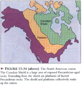
In North America, the Canadian Shield includes much of Canada; a large part of Greenland; parts of the Lake Superior region in Minnesota, Wisconsin, and Michigan; and parts of the Adirondack Mountains of New York. In general, the Canadian Shield is a vast area of subdued topography, numerous lakes, and exposed ancient metamorphic, volcanic, plutonic, and sedinientary rocks.
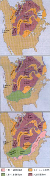
Each continent evolved by accretion along the margins of ancient cratons. To this extent, all continents developed similarly, but the details of each continent’s history differ. Here we shall concentrate on the evolution of North America. Several cratons that would eventually become part of the North American craton had formed by 2.5 billion years ago, but these were independent minicontinents that were later assembled into a larger craton.
A major episode in the Precambrian evolution of North America took place between 2.0 and 1.8 billion years ago when several major orogens developed. These orogens are zones of complexly deformed rocks, many of which have been metamorphosed and intruded by plutons and thus represent areas of ancient mountain building. Smaller cratons were sutured along these orogenic belts so that by 1 .8 billion years ago much of what is now Greenland, central Canada, and the north-central United States formed a large craton.
Following this initial stage of North America’s evolution, continental accretion occurred along the southern and eastern margins of the craton. No further episode of continental accretion occurred until the Paleozoic Era.
Orogeny and accretion during the last 570 million years occurred mostly along the eastern, southern, and western margins of the craton, giving rise to the present configuration of North America. During this time, the craton itself has been remarkably stable. It has periodically been invaded by the seas during marine transgressions followed by regressions, but it has been only mildly deformed into a number of large basins and domes.
In the east and south, the Appalachian and Ouachita mountains formed during the Paleozoic Era in response to compression generated by the closure of an ocean basin during the amalgamation of Pangaea. What had been passive continental margins became active ones as the ocean basin began closing. By the end of the Paleozoic Era, a continent-continent collision occurred, causing deformation in what are now the Appalachian and Ouachita Mountains.
During the Late Triassic Period, the first stage in the breakup of Pangaea began, with North America separating from Eurasia and North Africa. Along the east coast from Nova Scotia to North Carolina, block-faulting occurred and formed numerous ranges with intervening valleys much like those of the present-day Basin and Range Province of the western United States.
The valleys resulting from block-faulting filled with poorly sorted red-colored non-marine detrital sediments, some of which are well known for dinosaur footprints. Rifting was accompanied by widespread volcanism, which resulted in extensive lava flows and numerous dikes and sills. Erosion of the block-fault mountains during the Jurassic and Cretaceous periods produced a broad, low-lying erosion surface; renewed uplift and erosion during the Cenozoic Era account for the present-day topography of the Appalachian Mountains.
The North American Cordillera is a complex mountainous region in western North America, extending from Alaska into central Mexico. It has a long, complex geologic history involving accretion of island arcs along the continental margin, orogeny at an oceanic-continental boundary, vast outpourings of basaltic lavas, and block-faulting. Although the Cordillera has a long history of deformation, the most recent episode of large-scale deformation was the Laramide orogeny, which began 85 to 90 million years ago. Like many other orogenies, it occurred along an oceanic-continental boundary. The main Laramide orogeny was centered in the Rocky Mountains of present-day Colorado and Wyoming, but deformation occurred far to the north in Canada and Alaska and as far south as Mexico City. The Lewis overthrust of Montana resulted from Laramide compression, and in the Canadian Rockies, thrust sheets piled one upon another.
The Laramide orogeny ceased about 40 million years ago, but since that time the Rocky Mountains have continued to evolve. The mountain ranges formed during the orogeny were eroded, and the valleys between ranges filled with sediments. Many of the ranges were nearly buried in their own erosional debris, and their present-day elevations are the result of renewed uplift, which is continuing in such areas as the Teton Range of Wyoming.
In other parts of the Cordillera, the Colorado Plateau was uplifted far above sea level, but the rocks were little deformed. In the Basin and Range Province, block-faulting began during the Middle Cenozoic and continues to the present. At its western edge, the province is bounded by a large escarpment that forms the east face of the Sierra Nevada. This escarpment resulted from movement on a normal fault that has elevated the Sierra Nevada 3,000m above the basins to the east.
In the Pacific Northwest, an area of about 200,000 km^2 is covered by the Cenozoic Columbia River basalts. Issuing from long fissures, these flows overlapped to produce an aggregate thickness of about 1,000 m.
The present-day elements of the Pacific coast section of the Cordillera developed as a result of the westward drift of North America, the partial consumption of the oceanic Farallon plate, and the collision of North America with the Pacific-Farallon ridge. During the Early Cenozoic, the entire Pacific coast was bounded by a subduction zone that stretched from Mexico to Alaska. Most of the Farallon plate was consumed at this subduction zone, and now only two small remnants exist--the Juan de Fuca and Cocos plates. As discussed earlier, the continuing subduction of these small plates accounts for seismicity and volcanism in the Cascade Range of the Pacific Northwest and Central America, respectively. Westward drift of the North American plate also resulted in its collision with the Pacific-Farallon ridge and the origin of the Queen Charlotte and San Andreas transform faults.