|
|
|
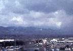
Warm Front Pattern |
|
|
|
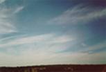
Cirrus |
Stratus |
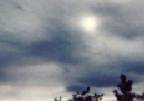
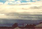
NimboStratus |
Cold Front Pattern |
|
|
|
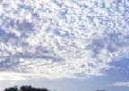
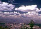
Cumulus |
Towering Cumulus |
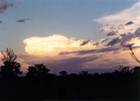
CumuloNimbus |
The west wind-- that is, wind blowing from west to east-- prevails across most of the United States, resulting in consistent, moderate weather. When wind from another direction takes over, get ready for change. If cold air from the north pushes south, for instance, it creates swirling, shifting winds that tip off the approach of chilly temperatures. Southerly or easterly winds often signal an approaching warm front. Here's a simple way to keep it straight: Wind in the west; weather at its best. Wind from the east, neither good for man nor beast.
For more specific weather clues, look to the clouds. They can signal fronts moving in at altitudes you'd never notice otherwise. Once again, change is the watch-word. Check the sky every few hours to gauge what kind of clouds are moving in. You can spot two kinds of storms this way: warm-front storms and cold-front storms. Each introduces itself with a particular sequence of cloud types.
Warm fronts travel relatively slow, which means you can often see them coming a day or two in advance. They tend to stick around for a couple of days with a pestering drizzle, or worse. "Mares' tails," or high, wispy cirrus clouds that hood at one end, are the first sign of warm fronts, according to John Patten, of the Meteorological Technical Institute in Helena, Montana. Cirrus clouds are composed of ice crystals high in the sky and look like a thin veil. They become mares' tails when strong winds in the upper atmosphere break the veil into wispy bands and push the ends into comma-like curves.
Mares' tails don't always foretell bad weather, so watch how these clouds change. If they increase and thicken, gradually lowering into a sheet of layered stratus clouds, you're in for as steady drizzle and , if it's cold enough, a good dose of snow. Stratus clouds are composed of ice crystals or, as the clouds lower, water droplets. If a drenching warm front is on the way, these stratus clouds will darken with moisture to become nimbostratus clouds with dense gray letters that block the sun. If a warm front is unstable and buffeted by high winds, you may see what mariners call a "mackerel sky" as the clouds form pockets that look like sheets of fish scales. An old folk saying can help you remember the early signs: Mares' tails and mackerel scales make lofty ships carry low sails.
Ice crystals in cirrus clouds can also create a halo or yellow ring around the moon, and the ring increases in size as the rain or snow clouds get closer. As the folk wisdom goes: The bigger the ring, the nearer the wet.
While you're waiting for a dreary warm front to pass, you can at least amuse yourself by looking for signs of clearing. Once stratus and nimbostratus clouds begin to lift and lighten, rain or snow will taper off and a few cloudy but drier days will likely follow.
Cold fronts, on the other hand, are the express trains of the weather world. They hit fast and furious, typically with only a few hours' warning. Before a cold-front storm, the sky is often dotted with billowy, cotton-candy clouds. Normally, these cumulus cloud signal fair weather, but if they begin to build into towers, a cold front is probably coming. These towers form when the clouds collide with a warm front, causing the water vapor to condense and "stack up."
At times the tops of these cumulus towers will flatten and form distinctive, swooping "anvils" due to fast, lofty winds. They become dark with rain, hail, or snow and transform into cumulonimbus clouds. These thunderheads often bring lightning and sometimes tornadoes, especially when pockets that look like upside-down muffin tins form along the underside. The good news is these fronts typically move out as quickly as they arrived, leaving the sky blue and the air crisp.
To keep warm- and cold-front cloud pattern straight, use this saying: Rain long foretold, long last; short notice, soon will pass.
Remembering the cloud sequences will also help.
 |
Cirrus |
 |
CirroStratus |
 |
AltoCumulus N: little change E: cloudy, possible showers S: showers and warmer W: little change |
 |
AltoStratus N: little change E: unsettled S: showery W: possible rain clearing |
 |
Stratus |
 |
CumuloNimbus N: slow improvement E: stormy, then showers S: slow improvement W: showers, then clearing |
 |
Cumulus N: clearing and cool E: increasing cloudiness S: thundershowers W: possible showers |